The Battle of Culloden 1746 was rather embarrassing for the English; although they ‘won’, without maps they couldn’t track the losers, who escaped. Such military requirements led to the formation of the highly regarded Ordnance Survey in 1791. Their first major initiative was to survey the coastline, as the main threat of war at the time was from France. That first 1 inch to the mile map of the Kent coastline, was published in 1801. It took almost 70 years to complete their first series of maps, which each cost 1-3x average weekly wage to buy. For your military ancestors you may wish to try to track their manoeuvres, perhaps using the battalion diary and OS maps.
Later public health, cholera epidemics and sanitation, drove map development and so cities were mapped. The first well recognised disease epidemiologist John Snow is famed for mapping the Broad Street cholera outbreak in London 1854, using bars to count the deaths in each household . In fact there were some errors in his map including the exact siting of the Broad Street pump! He was not a cartographer. Geographical accuracy was not important, his mapping of cases clearly demonstrated the cause. Removing the handle of the offending well soon led to the end of the outbreak.
Diseases can be mapped as they move around the world. Epidemics have sometimes been named for the area they were thought to arise in, often wrongly, as it is usually the place that first identified and acknowledges the problem. I prefer the Greek alphabet approach – today we are facing the Delta variant of Covid and delays to the easing of lockdown. Many health related maps are now available allowing us to compare, for example, the infant mortality rates, availability of doctors and life expectancy, in different areas, at different points in time.
Subsequent maps were driven by other specific needs – the requirements of the post office, insurance companies or automobiles. There is also a sense in which these services drove the need for specific addresses with street names and numbering. Such maps can add to our ancestor’s story or the background to their lives. If your blacksmith ancestor had fire insurance for example, insurance maps showing details of their premises may survive. For those with London ancestors the Booth Poverty maps (1886 -1903) are an amazing resource giving information about the standards of accomodation. Development of the canals, railway or road system led to increased mobility, contemporary maps can help predict migration – usually along the easiest route.
When studying One-Place such as Sticklepath, it is useful to study migration of the inhabitants, both in and out of the village. Perhaps looking at marriages to people in nearby villages, and how many move short medium and further distances, including abroad. I hope one day to have time to do this.
As genealogists we should really make notes on our own personal history for future generations. A simple exercise which does not need to be too time consuming is to document your own life through. the addresses you have lived at, perhaps if you have more time adding photos and notes on why and when your moves took place. In our own generation we are perhaps more mobile than those in the past.
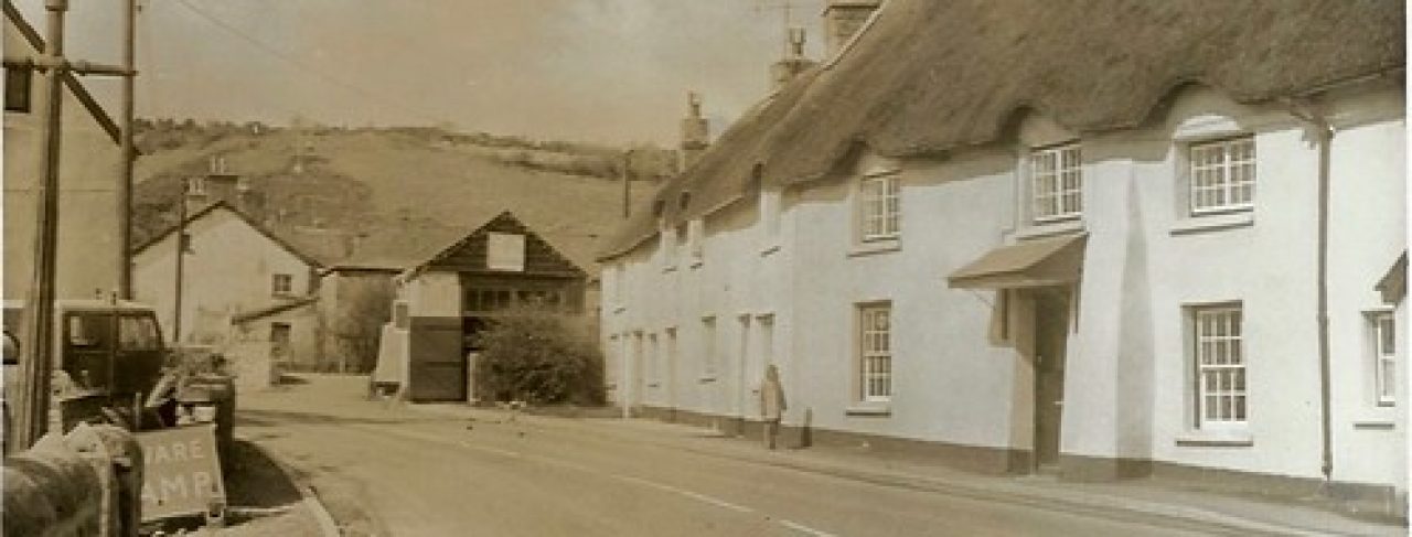
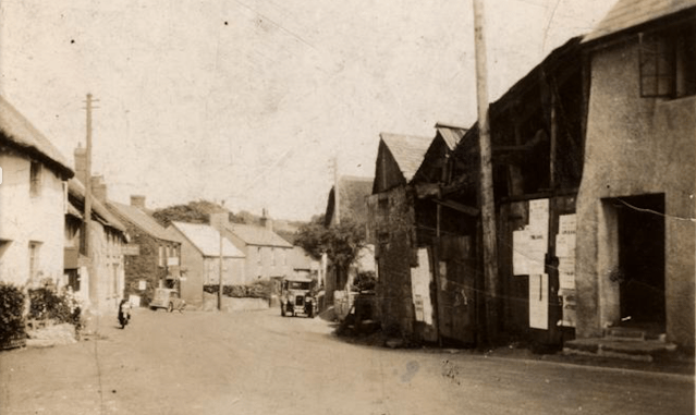
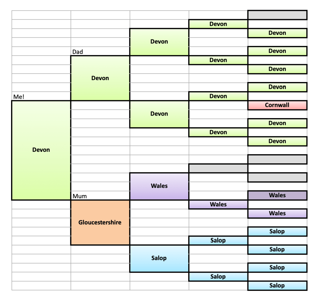
Sticklepath, a village on the North edge of Dartmoor, mid-Devon, England, was my father’s ancestors home for 200+ years. My grandmother and father lived in Sticklepath all their lives except for a few short years elsewhere in Devon for education and a few days in a maternity home. Dad did have a couple of holidays abroad. His father, son of an Ag lab moved around the farms surrounding Sticklepath, then settled in Sticklepath after marriage. (At 3 different addresses). He spent time in Gibraltar during the 2nd world war, returning to Sticklepath until he needed nursing care in Okehampton in his final months. My own address history in contrast is rather busy and mainly reflects training, occupation and holidays!
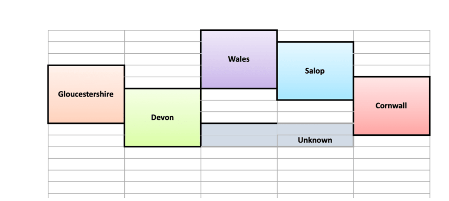
I was born in Okehampton Hospital and soon went home to Cleave house, Sticklepath. I went to senior school in North Devon, returning to Sticklepath during school holidays, then headed to the nearest medical school – in Bristol. However, I spent a year between school and university volunteering in Primrose Hill London, just North of Regent’s Park, and then looking after children with severe learning difficulties in Aberdeen. Moves after this were work related and fairly frequent during training. Addresses include Haverfordwest, Hemel Hempstead, Wigan, Bury (Lancashire), Exeter, Croydon. After marriage and qualifying as a GP, we settled in Cottingham near Hull. We later moved to Shrewsbury before volunteering for 2 years in a hospital in Blantyre, Malawi. On our return we lived in Cottingham again briefly before moving to Gloucester. On retirement we moved to be close to our grandson in York and now live in a village North of York. In amongst this I have been lucky to travel both with an elective to India for 9 weeks as a student and several long haul trips around the world.
I suspect the next generations will be more restricted in their worldwide travel, for economic, epidemic and environmental reasons as well as increased use of technology to reduce the need for business travel. Only time will tell…
For anyone interested in mapping ancestors and learning from look out for talks and blogs by Dr Sophie Kay – a truly inspirational speaker with stunning ideas!
