“Landmarks, by their pure existence, structure environments. They form cognitive anchors, markers, or reference points for orientation , wayfinding and communication. They appear in our sketches, in descriptions of meeting points or routes, and as the remarkable objects of an environment in tourist brochures.” (Richter and Winter)
Landmarks are often visible from a distance, or are features which, for a traveller passing through, mark One Place as different to another. I would add to that: ‘scars’, symbols or indicators in the environment which point to the history of our place.

Ladywell is mentioned in tourist information about Sticklepath, it represents both a physical landmark and landmark in history, before piped drinking water came down the street or into our houses. I surmise Ladywell would also have been an important social gathering point where people exchanged news whilst waiting to fill their containers. (Long before lock down, so no evidence of 2m marks!)

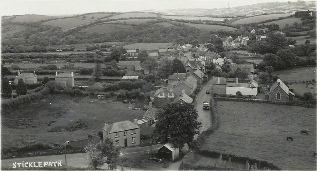
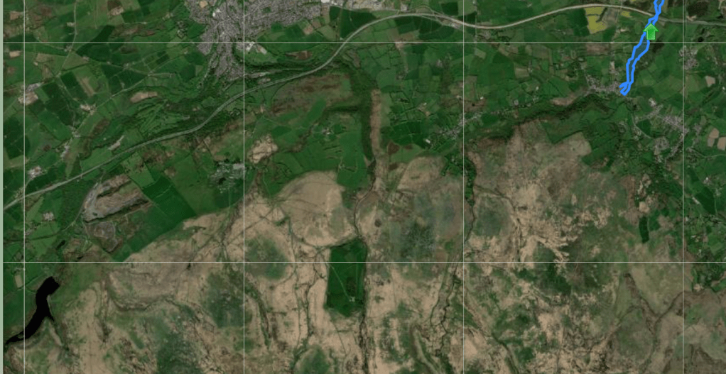
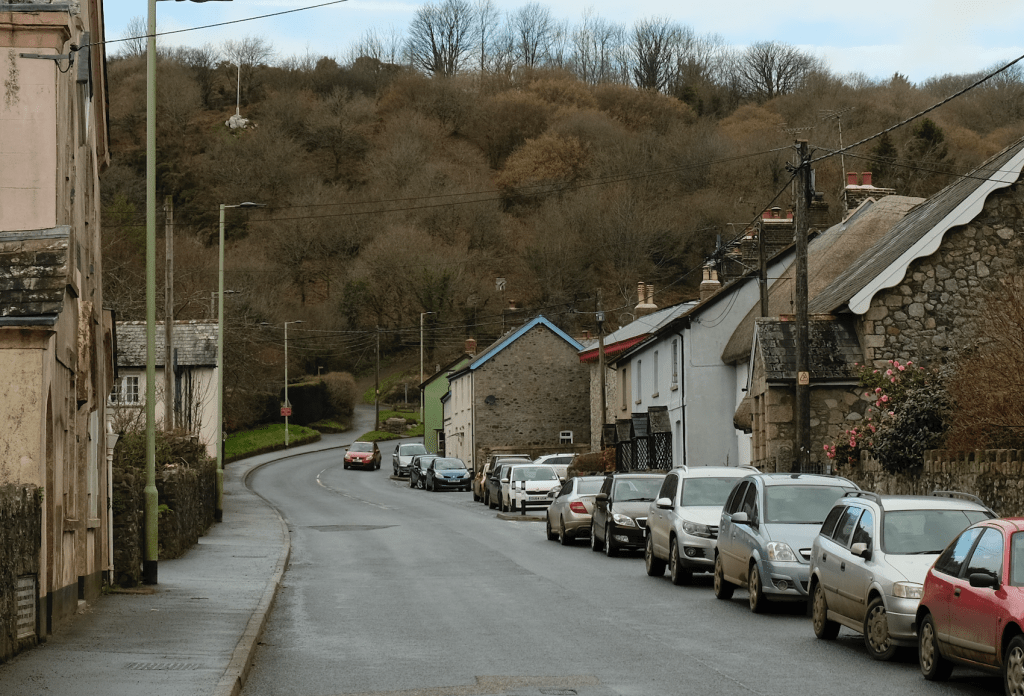
First let’s orientate ourselves using some other landmarks. As you travel through the village towards Okehampton and Cornwall, look past the small St Mary’s Church to see Ladywell on the left. Just there, by the roadside, as you start to notice the rise of the hill under your feet, with ‘White Rock’ and its flagpole on the Mount above.
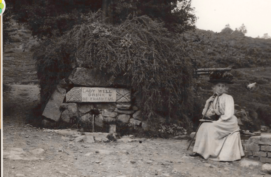
The tree and building are long gone, but find a pleasing bench on which to rest your weary legs, admire the village scene and ‘Be Thankful’. Probably not wise to drink!

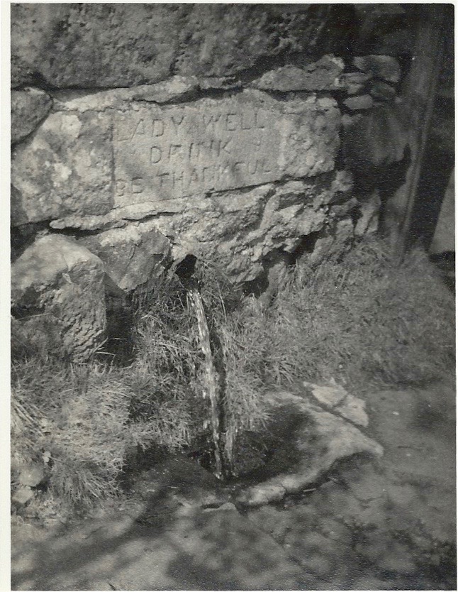
In about 1820 John Pearse, wool-stapler from Cleave Mill, had the overflow from Ladywell spring piped to the present Ladywell site, for the convenience of his Mill workers and the rest of the village. Ladywell much as we see it was built in 1831 – 2 yrs after the road was widened. A concealed pipe leads to a tank hidden beneath granite blocks and from there runs out through the short pipe we see, beneath the engraved lintel, ready to fill containers, to quench a thirst and flush the roadside drains.
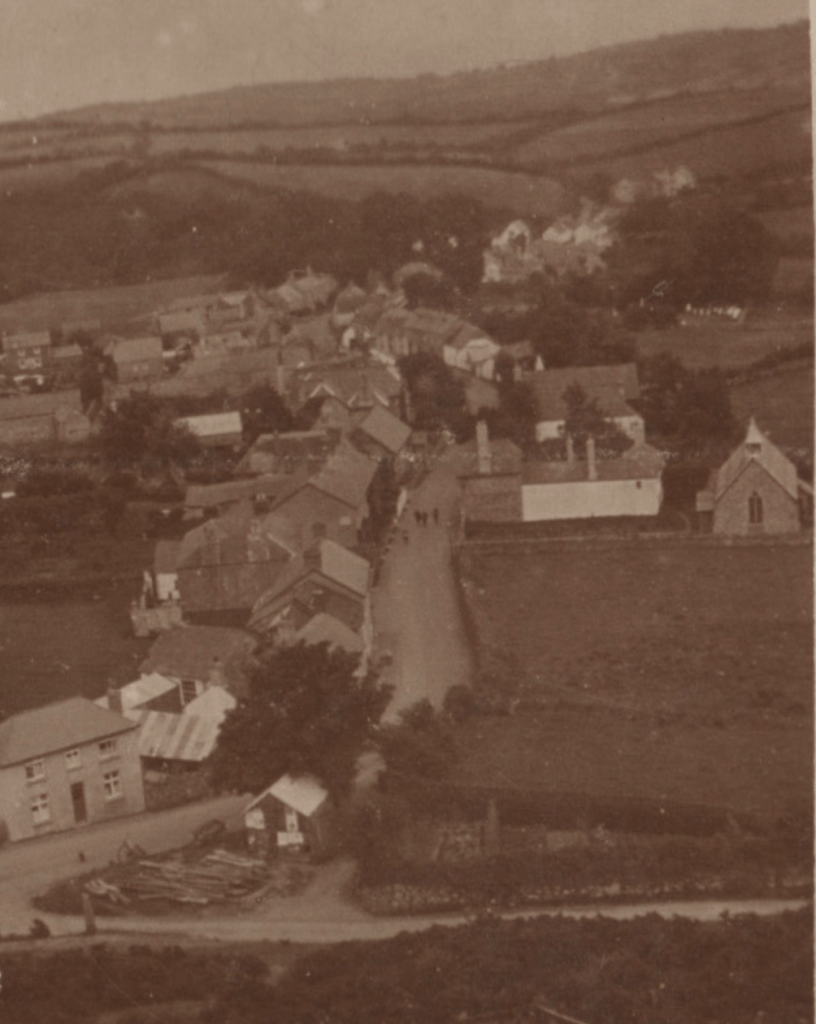

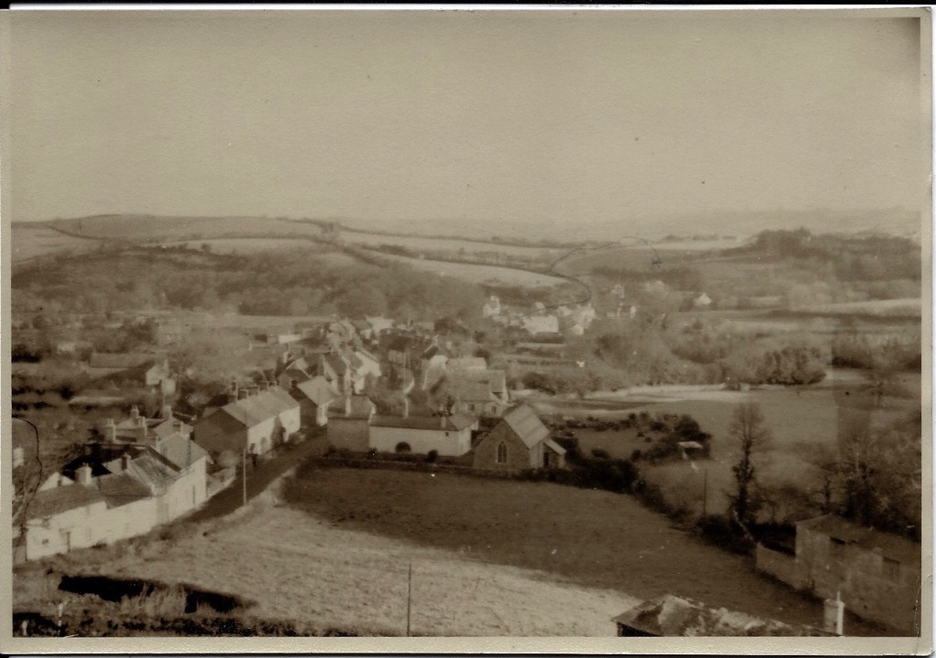
In fact Ladywell spring, essentially a round well 2 ½ – 3 feet diameter and perhaps 4-5 feet deep, is towards the top corner of a field known as Allermead, further up the hill on the opposite side of the road (see photo below for indication of where it is),
There has been some suggestion that this was a ‘Holy Well’ and that the origin of Allermead could be essentially ‘Hallowed meadow’. I am not aware of anything to support this but being close to the church it is possible it was at one time part of the incumbent priest’s lands.

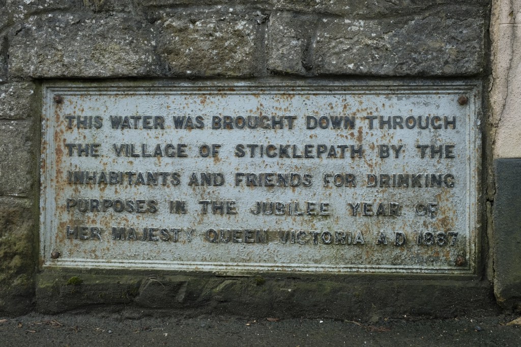
In 1887, the villagers arranged for the Ladywell water to be piped down the village street. This is commemorated on a plaque on the wall next to the chapel. (The wall was taken down and rebuilt with the plaque re-installed, when the road was widened). Being almost ‘outside’ the Parish, certainly not the main focus of Parish affairs, Sticklepath arranged many projects like this one without input from the Parish, relying on locals and wealthier well-wishers.

Jessie Barron tells us more in her book. Referring to living conditions following the 2nd world war she says:
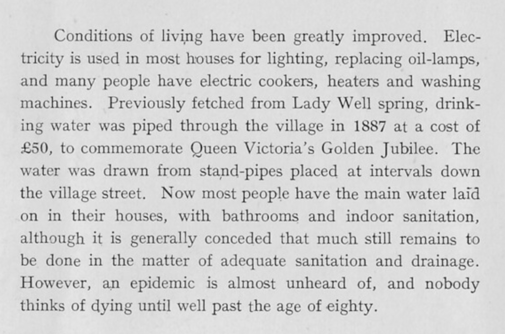

Her final sentence a timely reminder of the infection free, quality monitored, piped water we all take for granted, but which was a luxury innovation for our grandparents generation.
Dartmoor water whilst commonly considered ‘natural and pure’ can be contaminated in various ways, even on open moorland, due to the geology and farming – radon and radioactive carbon contamination, excessively acid and corrosive, high aluminium or other metal content, urine and faecal contamination, decaying matter upstream, and even vehicle pollution, for example.
Before moving on to the delightful subject of sewerage and Ladywell’s role, we turn to the building just above Ladywell, the shed in the foreground of Lugg’s photo:.
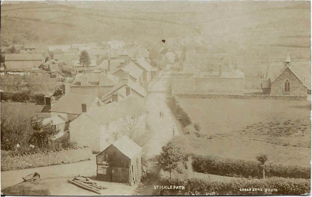
This substantial building with double ‘garage’ doors, is large enough to house a carriage. We can see posters on the lefthand side. This building was constructed and owned by wheelwright and carriage builder James Cook, as stated in his will. His workshop is on the lefthand side of the road part way between St Mary’s and Ladywell. The shed must have been demolished when the road was substantially widened and re-modelled here, perhaps in 1960s? We can see wood and a small cart on this photo. On photos further above there are wheels seen too around the shed.

Sanitation – A sewerage system of a reasonable standard came much later than piped water. Until then the Well was the means of flushing away household waste through the open drains on the North side of the road. Ladywell overflow ran into a ‘tip-tank’ beneath an iron grating. This was later replaced with a siphon mechanism. Waste from houses on the South side, however, just joined the leat water. Despite knowing this, most villagers on the South side freely dipped the leat for uses other than drinking, as it flowed just by their back doorsteps. Permission to use the leat water was written into most of their contracts.
In the middle of the 17th century the whole village and surrounding lands including mills and therefore the leat supplying them with power, was in the ownership of the Lethbridge family. By the late 18th century most was owned by the Underhill family. Conveyance of the Western and Carnall Mills (Eastern end of the village just by the bridge) from Richard Underhill to George Underhill includes permission to use the leat water for up to one hour a day to water Mill Meadow, and for him and the tenants of adjoining properties to use the leat water to wash their wool on payment of 6 pence per year. The leat itself and access to it remained the property of the mill owners. (Barron). However, they and I think Cleave Mill also, had to give one hour’s notice of wool washing to the Mills lower downstream.
The W.I.’s ‘The Book of Sticklepath (Dartmoor)’ in 1955 commented that not everyone had running water to their home yet:
“Some of the modern inhabitants of the village do the same today, leaving a pail or pitcher to fill under the steady trickle while they ‘run down the village’. ”
The village school which opened in 1879 is higher up the hill than Ladywell. This caused problems for water supply and sanitation. All drinking water was carried up the hill to school. In 1938 a Ministry of Health Inspector wrote
“The water has to be carried an unreasonable distance and I recommend that this matter is given urgent attention” (Hutchison)
It wasn’t until 1952 that a pump was installed to take water up the hill to the school. School toilets could be flushed using rainwater from holding tanks above the playground, as long as it had rained and was not frozen. These tanks were only disposed of in 1970 (the year I left the school!). There were times the tanks had to be filled, for example by Okehampton Fire Brigade during summer droughts, or by a Water Board Tanker during the freeze of winter 1960-61.
The main supply for Sticklepath village now, along with Belstone’s, is pumped from Meldon Reservoir, about 7 miles away. (I remember visiting the valley before construction of the damn began in 1970, and several times since).


Lion’s Mouth deserves a mention here, purely as a source of drinking water for residents of Skaigh Hamlet, and a pleasing stopping point on a circular walk from Sticklepath Bridge, along the banks of the Taw, through the Skaigh Valley. It likely dates from 1870 in it’s current form.
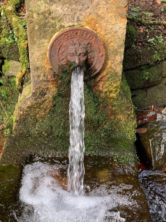
Rockside, as it is labelled, otherwise known as Skaigh House, one of the wealthiest estates, at one time owned by Symington who contributed greatly to our village including the building of Sticklepath Village Hall (Next week’s #Sticklepath #OnePlaceLandmark). Again drinking this water is NOT advised, after contamination was found in 2000 by the Environmental Agency.
Additional Notes: 1. Ladywell lends its name to a house on the opposite side of the road but that is not considered here. 2. We should also note residents at the East end of the village used a different spring behind the Taw River Inn in Skaigh Lane. 3. Further photographs of Ladywell can be found in “South Tawton & South Zeal – with Sticklepath – 1000 years beneath the Beacon by Roy and Ursula Radford, pages 26 and 61 – including Chapman postcard no10049, as well as a photograph by Douglas St Leger-Gordon in the WI booklet, those detailed show the position of the standing stone in relation to Ladywell better than those shown above). 4. Water supplies to parts of the village were complicated by being part of, and adjacent to, several parishes. The WI booklet again tells us: “When six ‘council’ bungalows were built down Willey Lane in 1953, pipes for their supply were attached to South Tawton mains, on the other side of the bridge.” 5. Historic England Research Records no 444182 says no evidence was found to substantiate a medieval date for Ladye Well, though the name might suggest a pre-reformation origin. 6. Sticklepath Conservation Area Appraisal suggests a 10th century date for the Ladywell stone, though this may refer to the standing stone rather than the lintel. Conservation Area Appraisal 2017 PDF – http://www.dartmoor.gov.uk. 7. Details of the history of the water supply to Belstone is given in The Book of Belstone (Walpole p131-134) much of which applies to Sticklepath, with various schemes to use Taw Marsh water proposed and some enacted.
Bibliography
Richter KF., Winter S. (2014) Introduction: What Landmarks Are, and Why They Are Important. In: Landmarks. Springer, Cham. https://doi.org/10.1007/978-3-319-05732-3_1
Sticklepath 1900-1950 by Jessie E Barron
The Story of Sticklepath (Dartmoor) Compiled by Sticklepath Women’s Institute 1955 reprinted with minor amendments 1993
A Village School Chronicle 1879-1979 Compiled and written by Victor J Hutchison
Robert A. Barron The Finch Foundry Trust and Sticklepath Museum of Rural Industry Printed by Jordan Phillips. ?1975
South Tawton & South Zeal – with Sticklepath 1000 years beneath the beacon. Roy and Ursula Radford 2000. Halsgrove.
The Book of Belstone (Words and images from a Dartmoor village) by Chris and Marion Walpole.
Will of James Cook from Gov.uk

Pingback: #OnePlaceLandmarks – the stories so far - Society for One-Place Studies
Pingback: Ramblings on #OnePlaceEnvironment – #Sticklepath – Sticklepath a Village and its People