BISHOP’s VISITATIONS

There are so many different organisations putting useful information online. It is hard to be aware of all of them. Friends of Devon Archives (FODA) is one you may not have seen.

FODA have placed online the Episcopal Visitation Returns made in 1744 and 1779 by Parish. Bishops were responsible for the morality and Christian teaching etc of each of their Parishes and these visits were part of ensuring things were being done properly. Preparations for the Bishop’s Visitation were considerable and included information gathered from each Parish incumbant. (For more information see Familysearch)

Sampford Courtney, Deanery of Okehampton

In 1744 (Chanter 225A, 358-359  ) the Rector of Sampford Courtenay was John Heath who was ordained September 24 1732 and started  this post October 12 1737. He  states that there are one hundred eighty nine families connected with the Church in Sampford Courtenay; there is one Family of Presbyterians and three of Quakers, though no licensed Meeting House, nor any fixed teacher.  There is a Charity School funded through contributions from the Parishioners, which opened “immediately after Xstmas” 1743, with up to 40 attendees. However, it was not well attended “for they are often shifting”, but teaching was given on the principles of the “Xstian Religion”.

There was no Alms house or Hospital in the Parish.  Thirty three pounds was held for support of the poor and ten pounds had been left by Sr John Ackland for “the binding out four children Apprentices” and a further “twenty shillings a year in land for the use of the poor”.

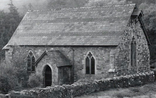
Rector John Heath states “I have a Chapel in My Parish call’d Stickle Path Chapel about five miles distant from the Parish Church and servd by my self twice in a year, and the Sacrament Administerd there each time as usual. There is likewise an old Ruinous Chapel call’d Brightly Chapel, to which I am presented by the College.”

By 1779  (Chanter 232B, 480) the Rev Rd Edwards was in post, ordained 1772 and instituted August 1772 in “Sampford Courtenay near Hatherleigh”. There were about 120 families. We have to assume Sticklepath is meant by:“There is a Chapel at a Village in the Parish where Service is performed by me twice in the year.”  At that time there were “neither Papists nor Dissenters” known to the priest. A legacy of 33 pounds & “the Rent of a Close amounts to 4 Shillings yearly, which is annually distributed” to the poor.  He also mentions some books left for the use of the priest by his predecessors.

These confirm the earlier impression I had of the Vicar coming twice a year to Sticklepath, basically to offer communion purely in order to collect his tithes!

Gladys Underhill and Jim Cooper Sept 1935

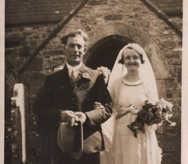
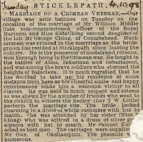
Churches were the focus of many life events, joyous or sad. My grandmother, Emma Lloyd Jones funeral April 1979 led by Rev Stark. Miss Kezia (Kate) Ching of Coombehead Farm married William Middle, Crimean war veteran 1898:

Saved newspaper clipping

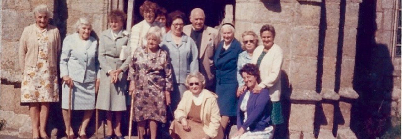
Do let me know of any events special to you at this little church. Do you have any photos or newspaper clippings to share?


St Mary’s Sticklepath is progressing well with renovations and is now raising funds for interactive boards for a heritage display. Please consider a donation. Do look at the page for a photo of how good it is looking inside.

‘Mapping your Ancestors’ A Simple Guide #OnePlaceMaps Part 3

The Battle of Culloden 1746 was rather embarrassing for the English; although they ‘won’, without maps they couldn’t track the losers, who escaped.  Such military requirements led to the formation of the highly regarded Ordnance Survey in 1791.  Their first major initiative was to survey the coastline, as the main threat of war at the time was from France.  That first 1 inch to the mile map of the Kent coastline, was published in 1801.  It took almost 70 years to complete their first series of maps, which each cost 1-3x average weekly wage to buy.  For your military ancestors you may wish to try to track their manoeuvres, perhaps using the battalion diary and OS maps.


Later public health, cholera epidemics and sanitation, drove map development and so cities were mapped.  The first well recognised disease epidemiologist John Snow is famed for mapping the Broad Street cholera outbreak in London 1854, using bars to count the deaths in each household .  In fact there were some errors in his map including the exact siting of the Broad Street pump!  He was not a cartographer. Geographical accuracy was not important, his mapping of cases clearly demonstrated the cause. Removing the handle of the offending well soon led to the end of the outbreak.

Diseases can be mapped as they move around the world. Epidemics have sometimes been named for the area they were thought to arise in, often wrongly, as it is usually the place that first identified and acknowledges the problem. I prefer the Greek alphabet approach – today we are facing the Delta variant of Covid and delays to the easing of lockdown.  Many health related maps are now available allowing us to compare, for example, the infant mortality rates, availability of doctors and life expectancy, in different areas, at different points in time.


Subsequent maps were driven by other specific needs – the requirements of the post office, insurance companies or automobiles. There is also a sense in which these services drove the need for specific addresses with street names and numbering. Such maps can add to our ancestor’s story or the background to their lives. If your blacksmith ancestor had fire insurance for example, insurance maps showing details of their premises may survive. For those with London ancestors the Booth Poverty maps (1886 -1903) are an amazing resource giving information about the standards of accomodation. Development of the canals, railway or road system led to increased mobility, contemporary maps can help predict migration – usually along the easiest route.

When studying One-Place such as Sticklepath, it is useful to study migration of the inhabitants, both in and out of the village. Perhaps looking at marriages to people in nearby villages, and how many move short medium and further distances, including abroad. I hope one day to have time to do this.

As genealogists we should really make notes on our own personal history for future generations. A simple exercise which does not need to be too time consuming is to document your own life through. the addresses you have lived at, perhaps if you have more time adding photos and notes on why and when your moves took place. In our own generation we are perhaps more mobile than those in the past.

Sticklepath, a village on the North edge of Dartmoor, mid-Devon, England, was my father’s ancestors home for 200+ years. My grandmother and father lived in Sticklepath all their lives except for a few short years elsewhere in Devon for education and a few days in a maternity home. Dad did have a couple of holidays abroad. His father, son of an Ag lab moved around the farms surrounding Sticklepath, then settled in Sticklepath after marriage. (At 3 different addresses). He spent time in Gibraltar during the 2nd world war, returning to Sticklepath until he needed nursing care in Okehampton in his final months. My own address history in contrast is rather busy and mainly reflects training, occupation and holidays!

I was born in Okehampton Hospital and soon went home to Cleave house, Sticklepath. I went to senior school in North Devon, returning to Sticklepath during school holidays, then headed to the nearest medical school – in Bristol. However, I spent a year between school and university volunteering in Primrose Hill London, just North of Regent’s Park, and then looking after children with severe learning difficulties in Aberdeen. Moves after this were work related and fairly frequent during training. Addresses include Haverfordwest, Hemel Hempstead, Wigan, Bury (Lancashire), Exeter, Croydon. After marriage and qualifying as a GP, we settled in Cottingham near Hull. We later moved to Shrewsbury before volunteering for 2 years in a hospital in Blantyre, Malawi. On our return we lived in Cottingham again briefly before moving to Gloucester. On retirement we moved to be close to our grandson in York and now live in a village North of York. In amongst this I have been lucky to travel both with an elective to India for 9 weeks as a student and several long haul trips around the world.

I suspect the next generations will be more restricted in their worldwide travel, for economic, epidemic and environmental reasons as well as increased use of technology to reduce the need for business travel. Only time will tell…

For anyone interested in mapping ancestors and learning from look out for talks and blogs by Dr Sophie Kay – a truly inspirational speaker with stunning ideas!

‘Mapping your Ancestors’ A Simple Guide Part 2: Walking in their footsteps #OnePlaceMaps

Another simple idea is to look at a large scale detailed map and work out an ancestor’s likely route to school or church or work. Best on a map of their era or if using a modern map, be aware of possible changes. Ideally actually walk the route or do so online on something like Google street map. Ask yourself questions about what the experience of walking in their shoes might have been:

Do they pass a market or perhaps a blacksmith’s forge – imagine the noises and smells. like that of the Finch Foundry in Sticklepath, dominating the main street.

Finch Foundry on right. One of the photographs from Mr Stead’s collection, now available on https://dartmoortrust.org/archive/record/103308

What sights were there, views or landmarks, features or milestones? How would that vary in the seasons or over time? How would it look different to today? Types of architecture, specific features of the buildings? Looking at ‘listed’ buildings online can be helpful

What help might your ancestors have needed eg where was the nearest workhouse? Any charitable institutions nearby? Fire service? Police? Do you know where the Police House was in Sticklepath? Initially near the Bridge, later Pixie Nook, on the way out of the village towards Okehampton.

Where is the graveyard? Non-conformists may not have used the Churchyard. Some places like Sticklepath have an ecumenical burying ground.

Trade directories can add more information and help looking for businesses your ancestors might have used or worked at. 

Don’t forget to make a note of your findings! I have made a start on a detailed Walk through Sticklepath’ essentially following the main street through the village and noting anything of historical interest along the way.

(Snowy Footprints Image by jenlargo88 from Pixabay)