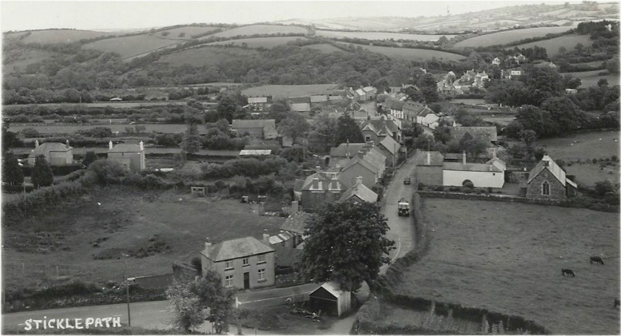
What does one call a collection of landmarks? A Glut? An Album? A Crowd? I have settled on a ‘Tour’ of landmarks, from right to left on the map below. Some will be the focus of a blog, but not all!
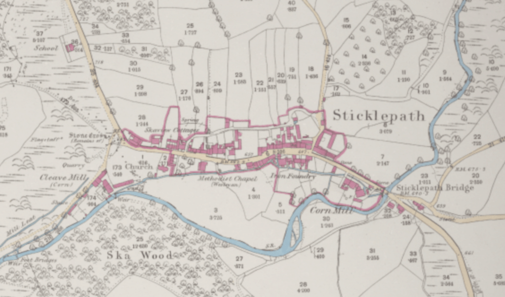
The British Library 25 inch 1841-1952 ℅ The National Library of Scotland website. Many landmarks marked (1886) eg Bridge, cornmill, foundry, chapel, Ska or Skaigh View Cottages, church, stone ‘cross’, flagstaff, quarry, Cleave Mill, mill leat. School also (top left – no image available)
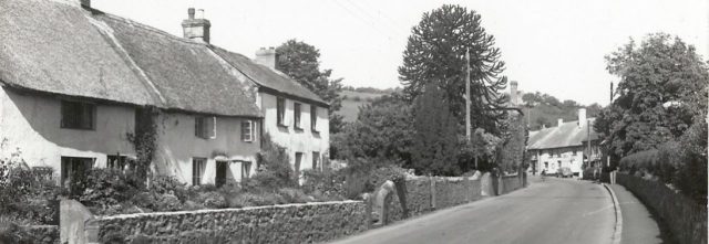
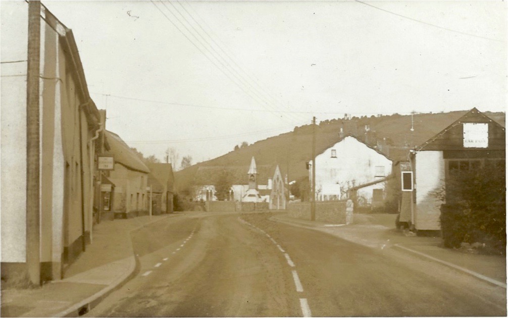
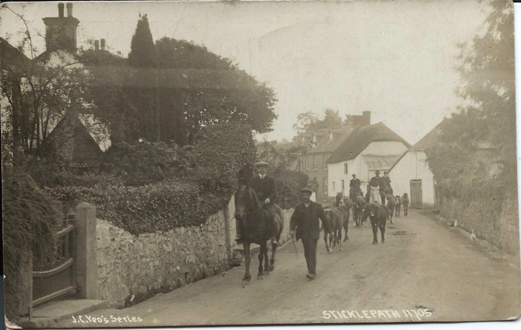
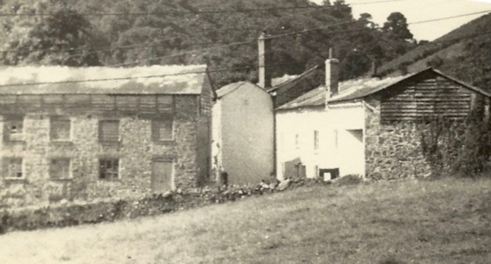
View entering Sticklepath “Western and Carnoll” mills on left side behind white Bridge House, with row of Elm Trees on right, pre-1928 Top left corner quarry below ‘White Rock’ with its flagstaff. School seen half way up the hill to right of midline.
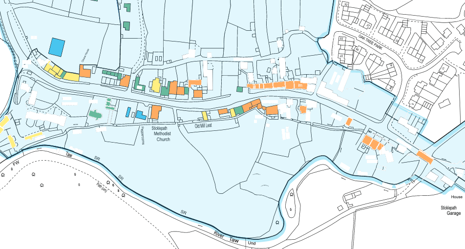
Part of Sticklepath Historic Quality and Integrity map page 19 of Sticklepath Village “Conservation Area Character Appraisal” June 2017 by Dartmoor National Park Authority. Grade II or II* listed buildings and features marked in orange, images below where I can.
The River Taw flowing under Sticklepath Bridge 1905 approx.
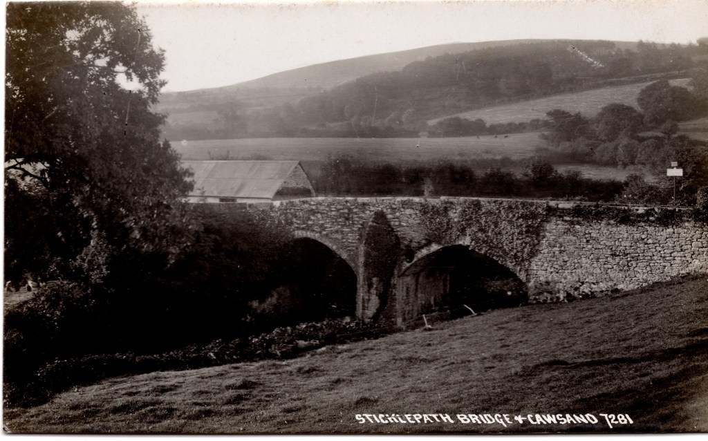
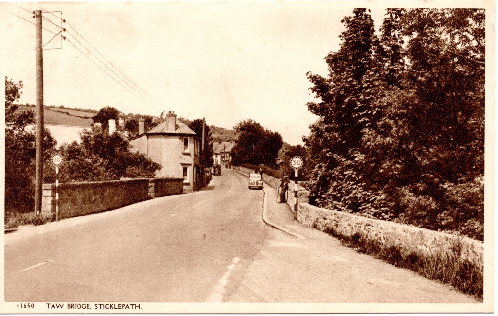
View across the bridge. 1930s?
A plaque commemorating the bridge widening 1928 and old parish boundary stone Sampford Courtenay to South Tawton
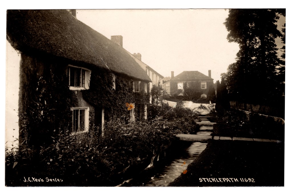
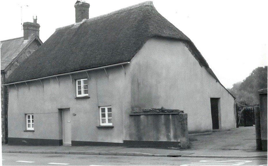
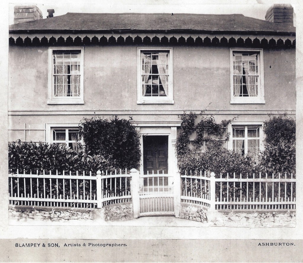
Mill House, Taw Leat and Silverlake, (listed). The Monkey Puzzle tree let me know I was home in 1960s.
The leat runs uniquely in front of these houses, then to the left of Primula the house facing us and behind all the other houses. Note the large granite slabs forming bridges over the leat. Chapman postcard, I presume commissioned by Yeo of Sticklepath Post Office. 1910s
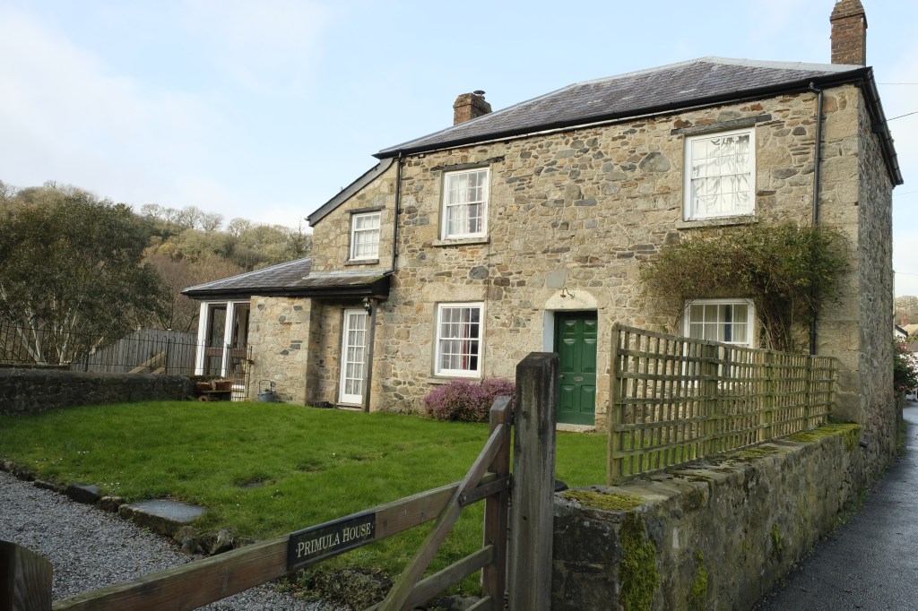
Primula House (Previously Temperence). Inset County ‘C’ stone adjacent to the road. 2019
C stone marking the extent of road maintenance from the bridge by the County, built into side of Primula House (listed)
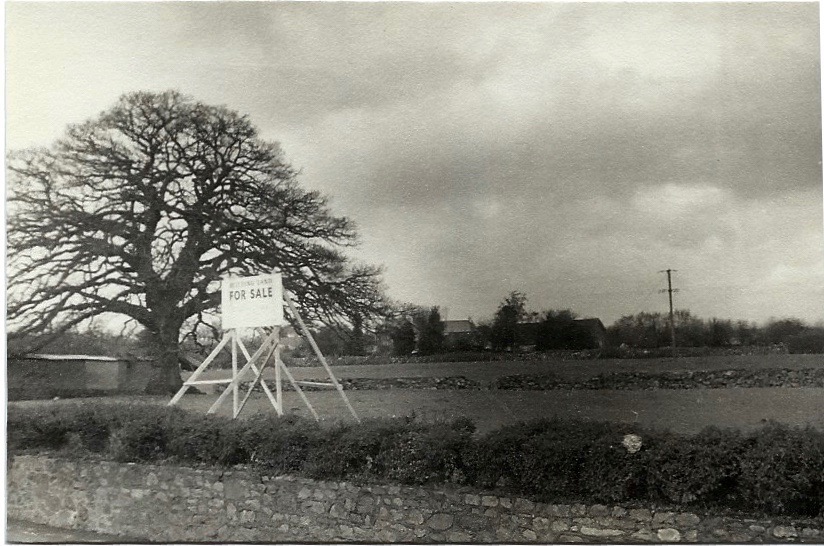
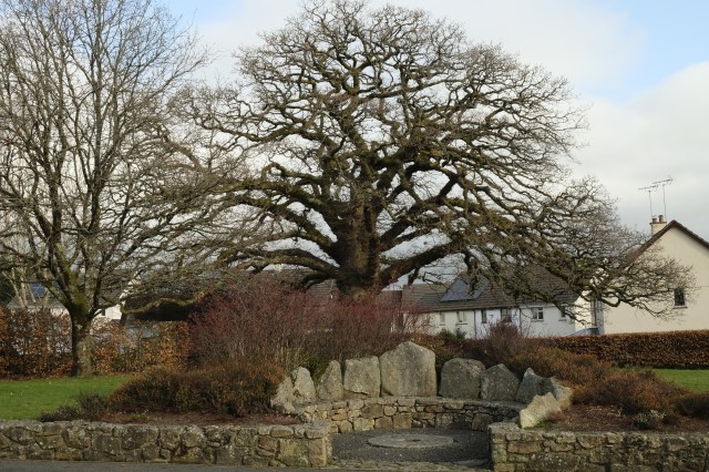
On the opposite side of the road, Oak tree in field for sale in 1970s
Same oak tree with the Millennium Seat (2000) and Oaktree Park Houses (photo 2019)
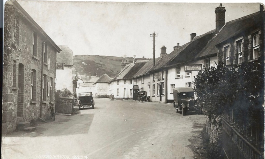
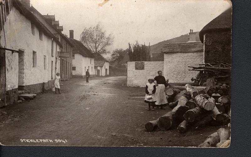
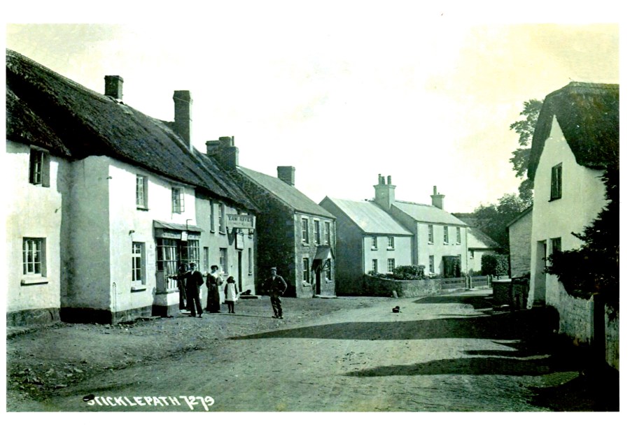
Walking on, the White House on the left was the first post office, then the house on the right by telegraph pole, the two small cottages closer to us on the left took turns being the post office later. Much more recently it moved across the road to the now Village Stores, first building on the right. The Taw River ‘Hotel’ is seen. The black porch marks ‘The Dairy’. The thatched square white building protruding in the distance is where the candle factory was.
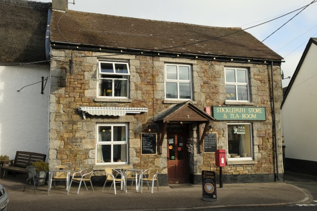
Village shop 2019
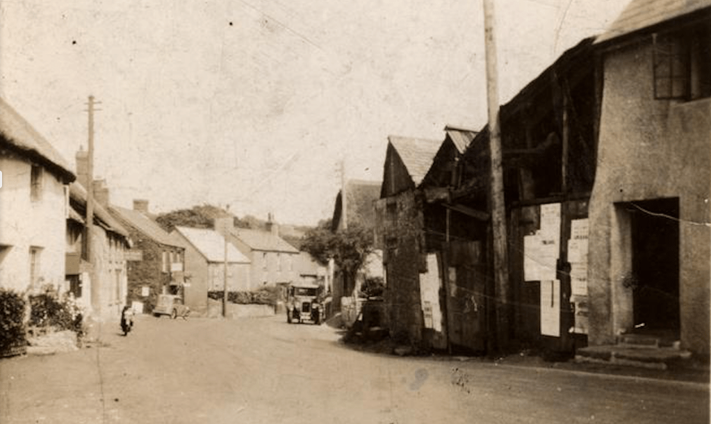
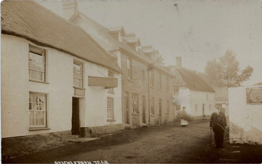
The Taw River Hotel, now Inn. Beyond this the full run of thatched cottages are listed. The man standing by bay windows at the post office of the time. The black area on the left is the smithy known as the Finch Foundry.
Commercial postcard. Photo by Roger Bowden, I am the child in the photo walking past Tudor Cottage and the porch far right is ‘The Dairy’. Mid-1960s. As noted above this whole row of thatched cottages is listed.
Looking back at the Taw River Inn and Village Shop on left. Black buildings on right are Finch Foundry.
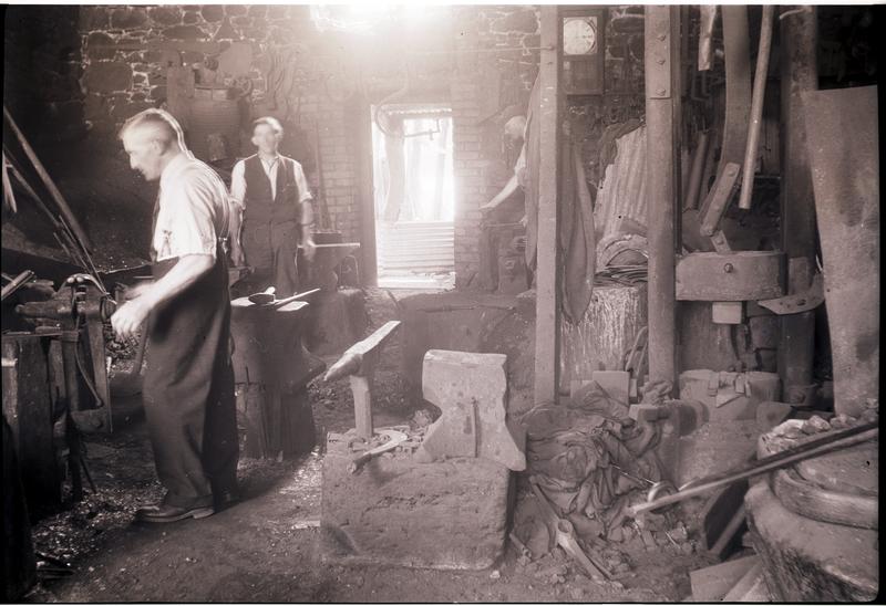
Ralph Finch at work ?late 1950s
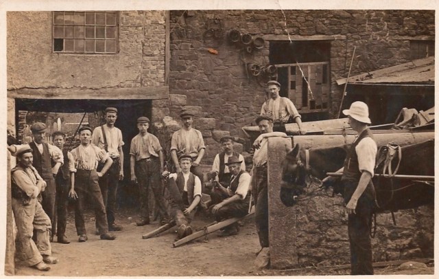
Foundry workers ?1920s (Young Ralph Finch with hand on hip)
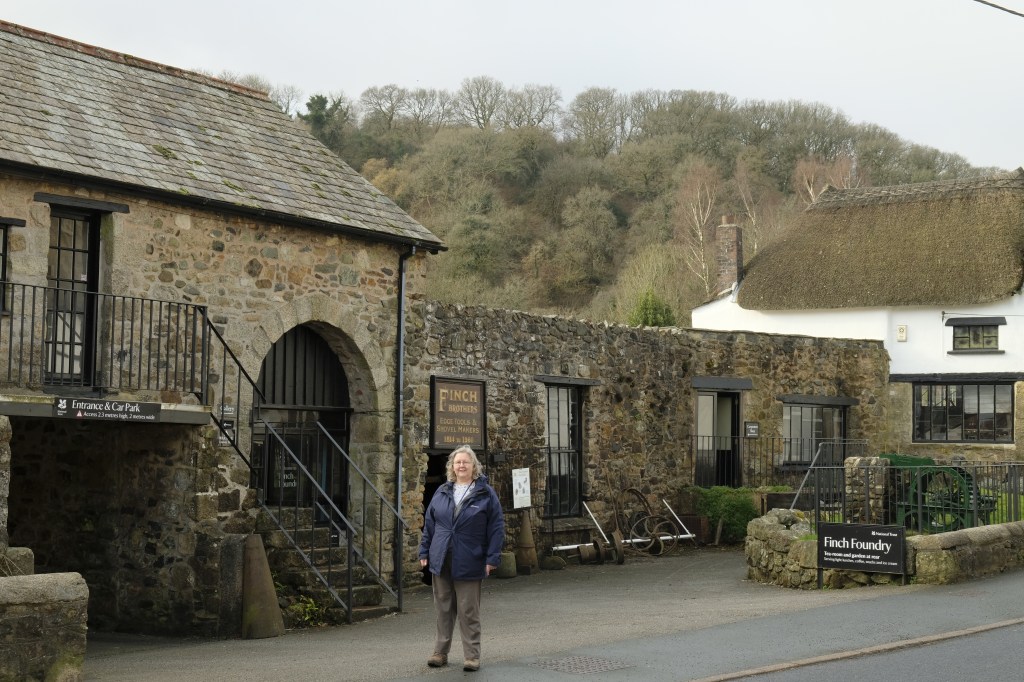
2019 Finch Foundry National Trust (Helen Finch Shields in foreground)
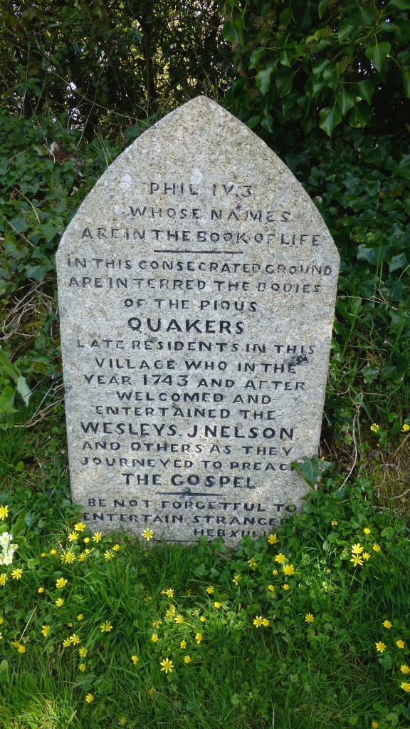
Behind the Foundry site is the village graveyard ‘Quaker Burying Ground’, non-denominal since 1830s.
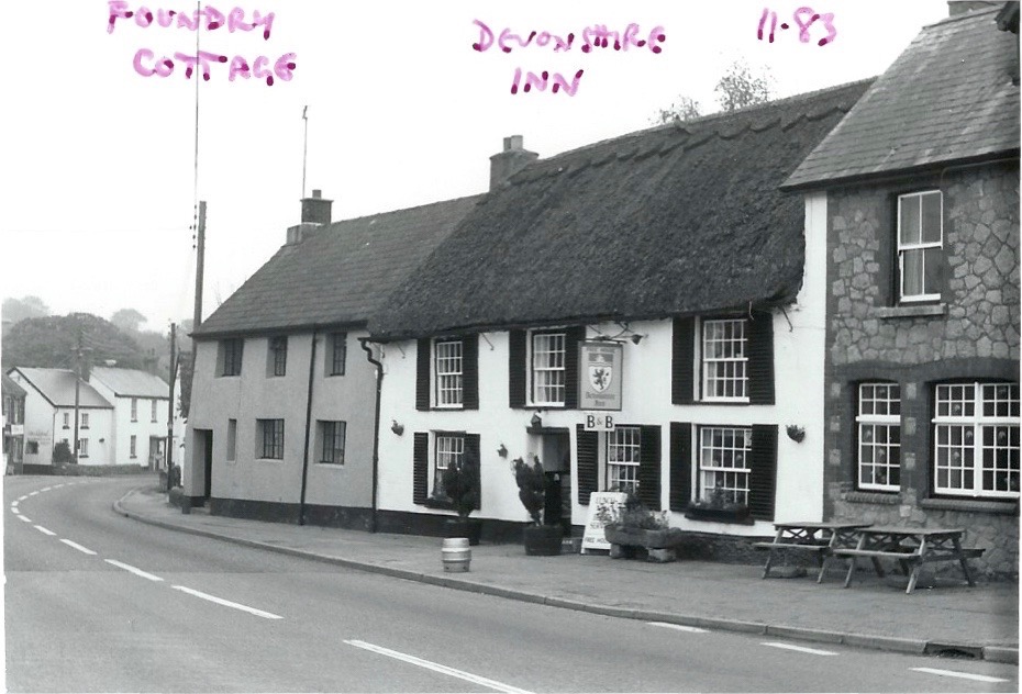
Grey house is Foundry Cottage (listed). Devonshire Inn then two more modern houses, perhaps late 19th century.
Foundry Cottage closest on left. Candle factory on right.
The Devonshire Inn. Note dormer windows, not many on Sticklepath Main Street. Chantry Cottage white house in distance. William Middle, Crimean war veteran walking down the village. Photo about 1905?
The Devonshire can be seen on the left and a new bay window further on where the Post Office resided then. A bus stop is now sited in front of this and Chantry cottage. Much road widening on the right and pavements added. Large White House on right is Sunnyside. No bus shelters ?1970
Chantry Cottage (listed) 1983. Muriel remembered buying Clotted cream here about 1910
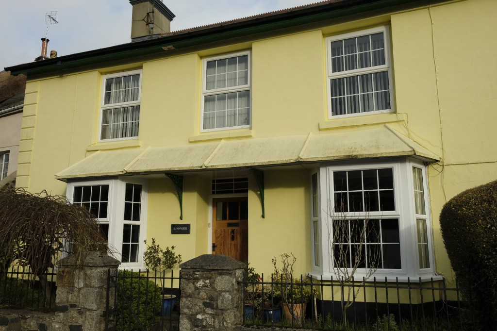
Sunnyside. Home of ‘Butcher Cook’, early 1900s, a generous village character who was Chair of Governors of the village school. (2019)
Sunnyside (listed) 2019
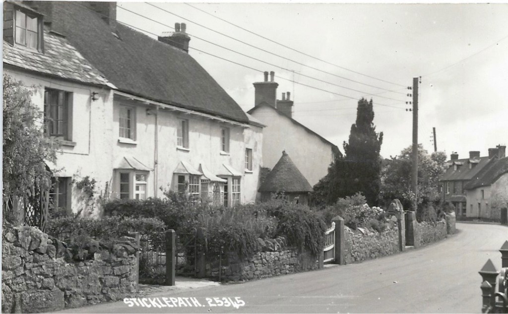
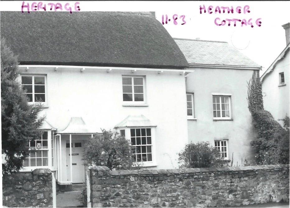
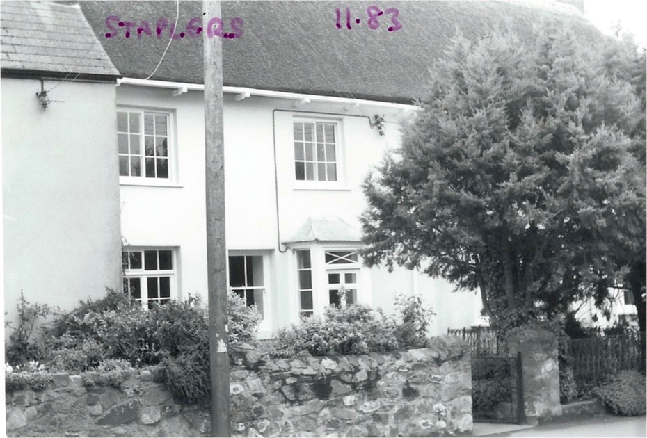
Further on we turn back, Chantry cottage still visible on the right, We see Thomas Pearse’s small round summerhouse in the centre with Sunnyside behind. (Now re-sited in Foundry grounds). The thatched cottages on the left are Staplers and The Heritage. Gutters on thatch are unusual but there are plenty in Sticklepath! Stone walls as seen here are common throughout the village.
The Heritage, a Quaker’s house 1800s and Heather Cottage tucked back (Photo 1983)
The Heritage 2019
Staplers (built by wool staplers) photo 1983. Crossing over the road again….
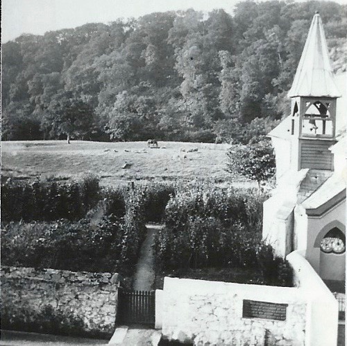
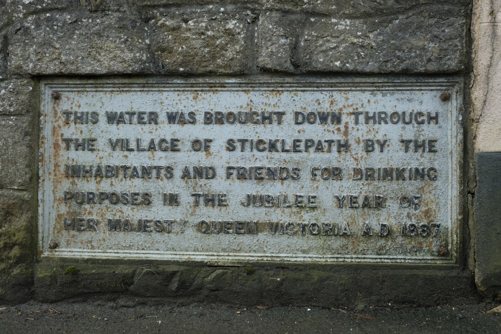
One of the few remaining open views to countryside from the village street. Commemorative Plaque, prior to road widening 1928. I think a stand pipe tap can be made out below the plaque. Unusual Bell tower on Wesleyan Methodist Chapel.
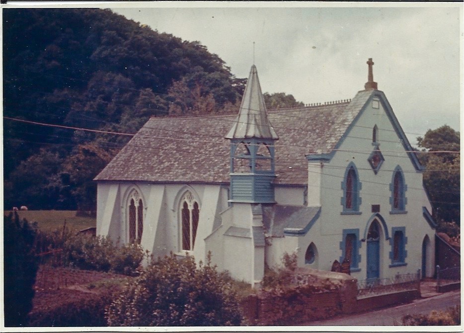
Wesleyan Methodist Chapel, (listed) again prior to road widening 1928. Sometimes blue and sometimes painted maroon and pink over the years. The poles, street lights and wires detract from the picturesque village still today. Stone cross on top of unknown origin.
Plaque replaced lower down when the wall was re-built flush with the front of the chapel (no watery pun intended)
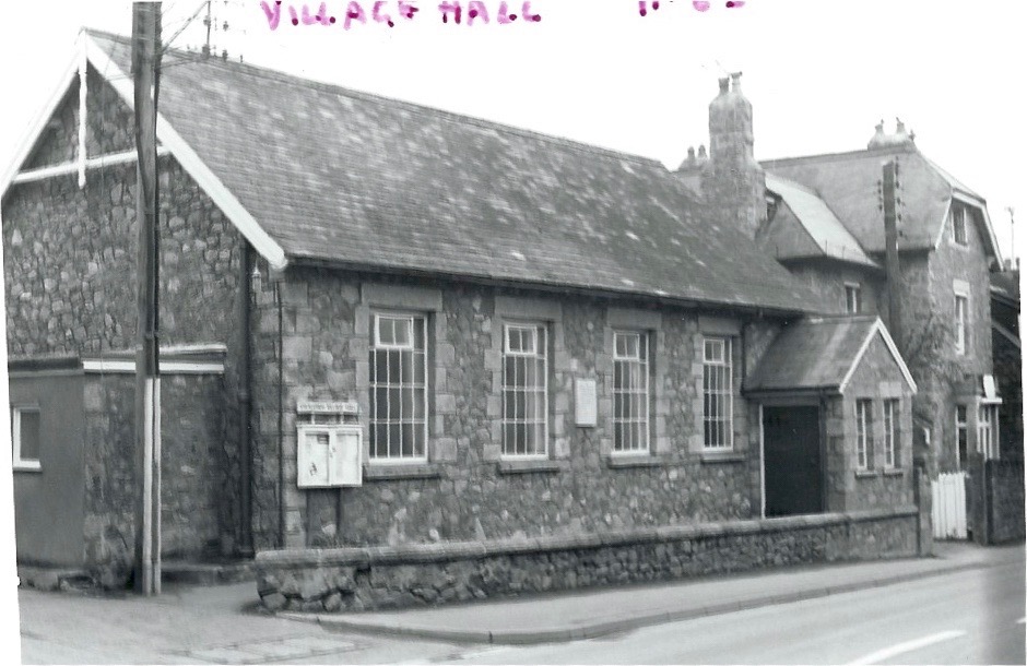
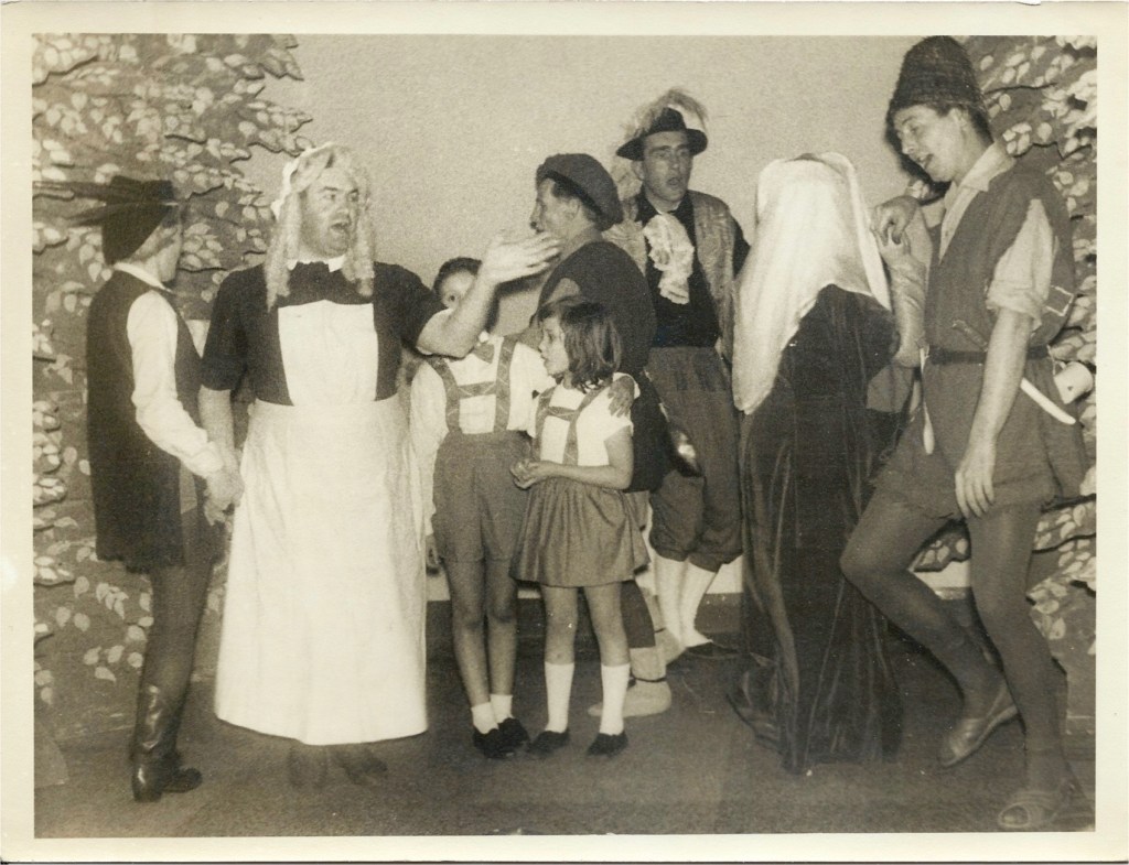
Village Hall with Tawburn House behind (Private house, later care home, now boutique hotel) Photos 1983 by Roger Bowden
The village hall was a centre of social activity. Bert Stead and villagers performing Babes in the wood 1960s (Photo R.Bowden)
The Old Cottage, between village hall and Skaigh Cottages had 4 entrances/seperate living areas, we see 3 entrances here. An early lamp post. In front of the houses to the left you can see the drain with which flushed household waste away, with stone bridging to each house. I note many stone walls were whitewashed in the past. 1910s?
The Old Cottage 2019. (Front wall clearly moved back to allow for pavement and road widening)
View on up the street, plaque visible bottom left, chapel (sadly dilapidated pink) and opposite is the village hall and row of 4 Skaigh View Cottages with matching porches, the old stables behind them and well pump are of some historical interest. (Photos 2019 by Michael Shields)
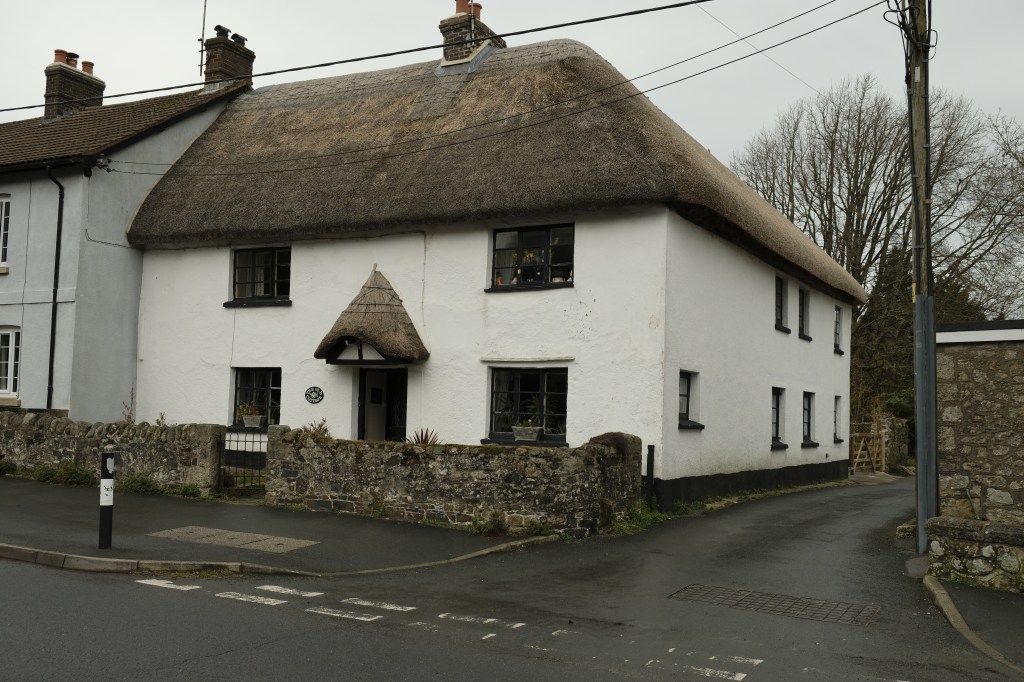
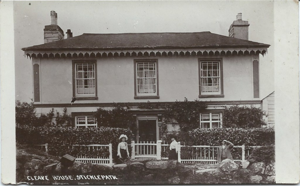
Cleave House, listed. ( The outline floor area is very similar to The Old Cottage)
Cleave House demonstrating the uneven glass panes. I think the iron railings were taken down during WWII?
Cleave House, built 1850s, likely by Mill owners, Ska or Skaigh View Cottages built soon after perhaps for their workers. Photo late 1970s?
Note the black wheelwright’s mandrel and the long rows of high windows are where his workshop was, labelled as ‘smithy’ on some maps. The upstairs was 23 foot length.
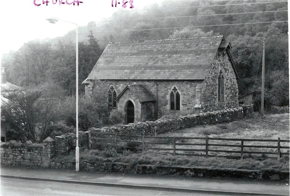
St Mary’s (Anglican) Chapel of Ease. 1983. At the top of this field on the right as we look …..
Remains of the Cleave Mills. Late 1960s? Would have been a landmark up to that time.
Mill buildings from far side showing closeness of Taw and also conversion to accommodation (Photo 2019)
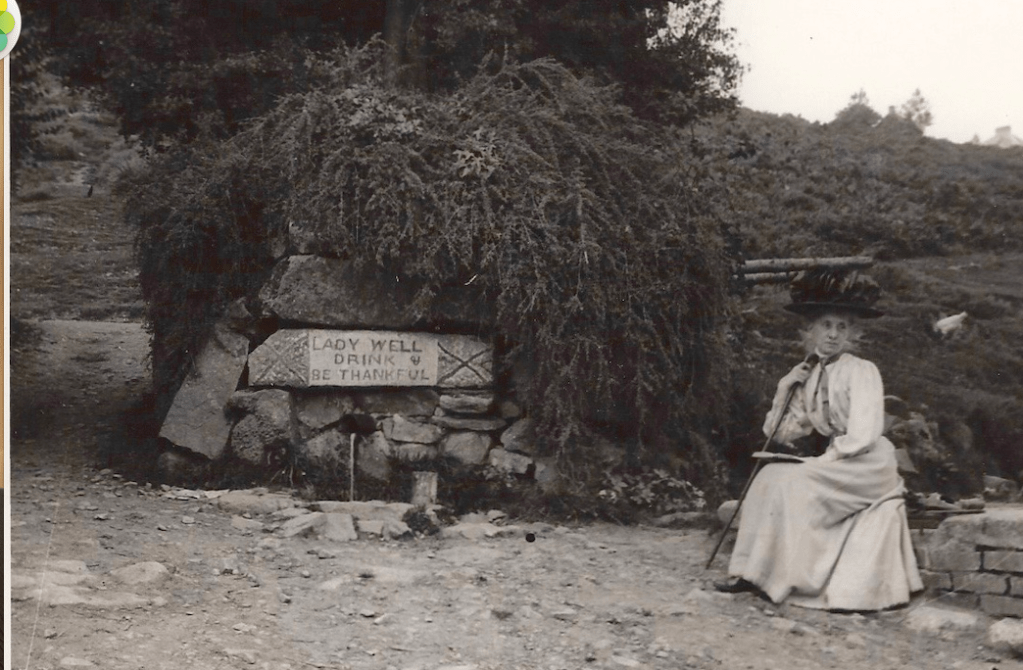
Ladywell. Mrs Elderton
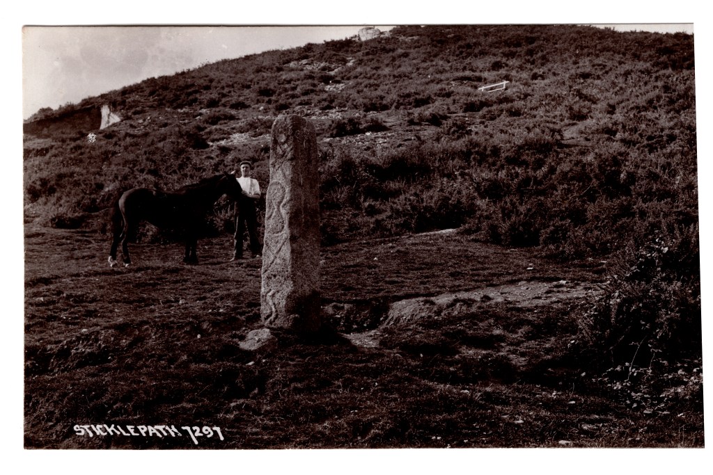
Standing stone, Parish boundary marker, showing inscription, now much corroded. Pre-1910?
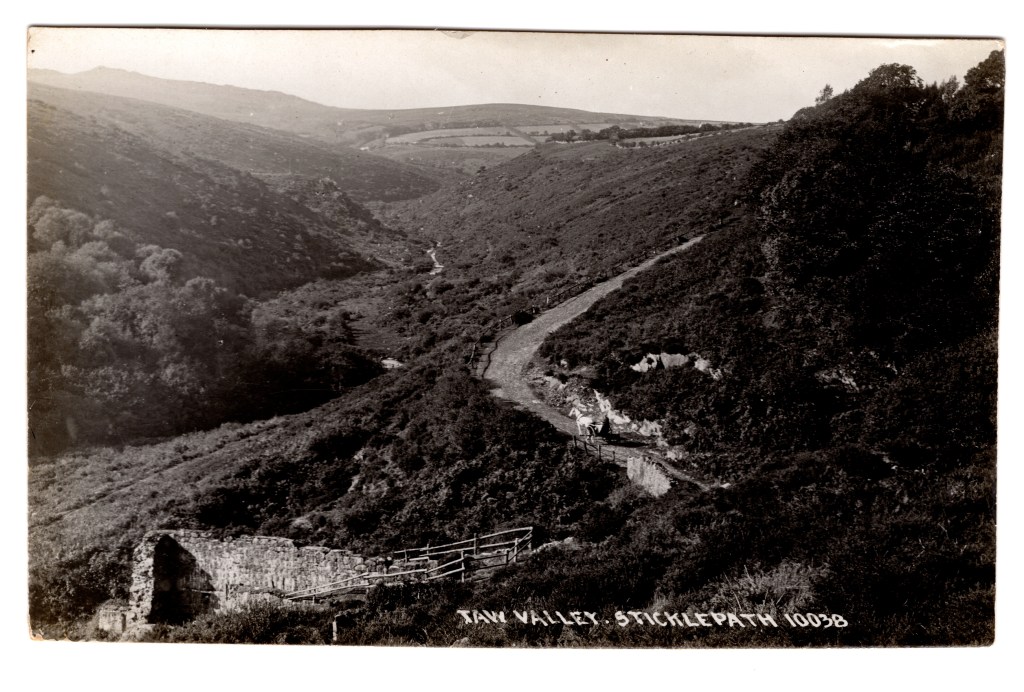
Further up the lane to Belstone in the Skaigh Valley used to be visible the remains of the largest waterwheel in Mainland Britain at 70 ft diameter.
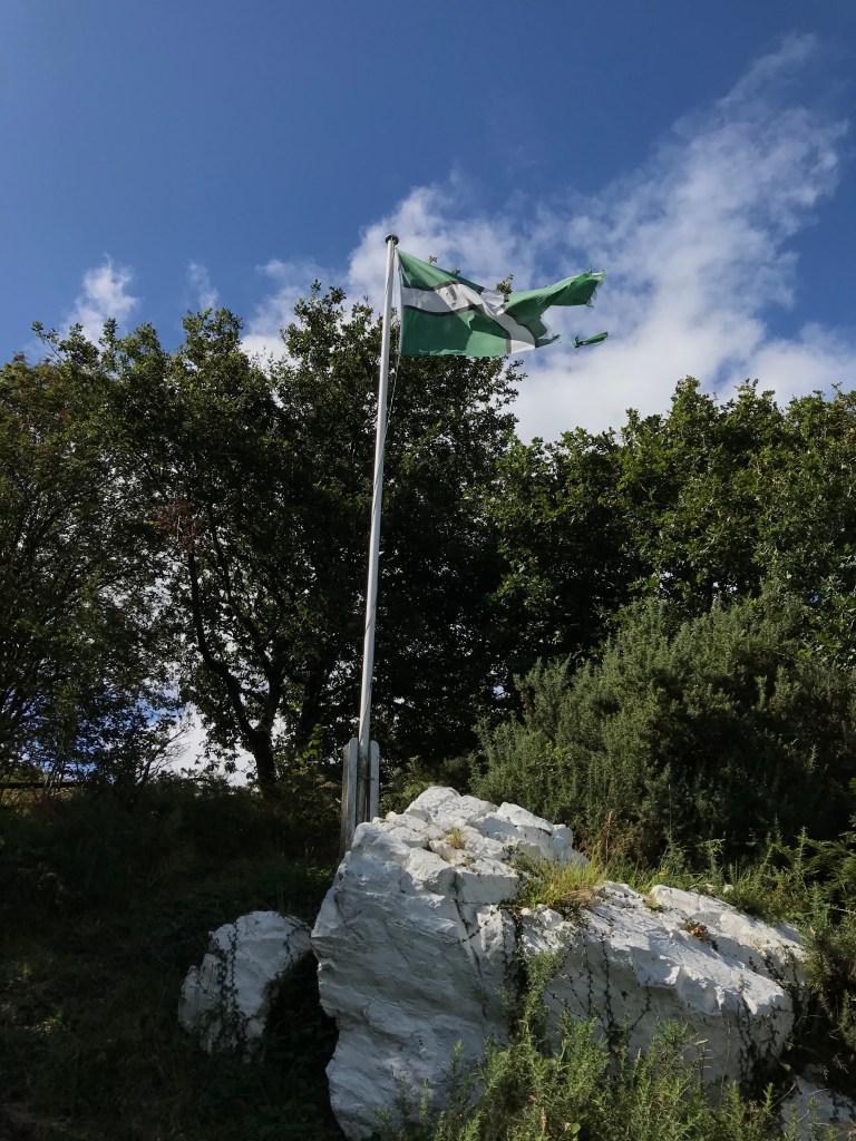
White Rock and flag pole. Wesley is said to have preached here
Many dates for the photographs are guesses. Please add comments if you spot something that suggests a different date or you have more information. I am always pleased to hear thoughts or opinions. Do contact me if you have any questions or any photos to add!
This is my first post for 2021, and first in a series for #oneplacestudies, #oneplacewednesday and January’s topic of #oneplacelandmarks. I would like to capture, for posterity, memories, knowledge and views of what it is or was like to live in, work in or visit Sticklepath. PLEASE comment on this post or with your thoughts about Sticklepath. I love to hear family stories, especially if backed up with sources or evidence. If this is your first or an occasional ‘visit’ to Sticklepath on the edge of Dartmoor – WELCOME! Please do come again!
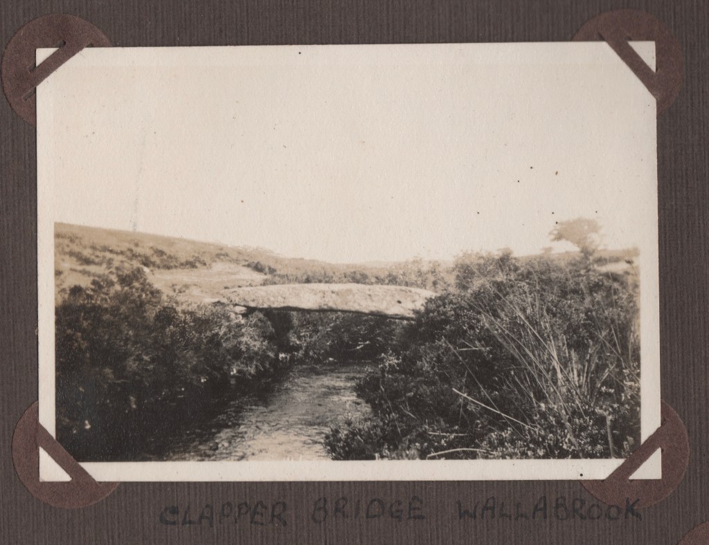
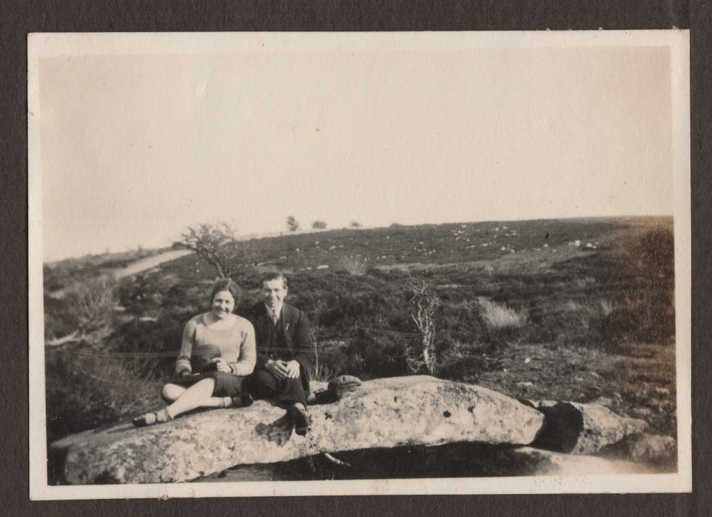
There are many bridges on Dartmoor, primarily constructed of the local stone – granite. The earliest and simplest are clapper bridges, a single piece of granite laid across a waterway or gulley. Wider gaps would have required a central column or pier and two slabs, and so on. Many were (and are) tourist attractions, such as Wallabrook. A Clapper Bridge over the Teign, this was a favourite location for a picnic and family day out from Sticklepath in the 1920s, as Phyllis Finch’s album shows:
Wallabrook Clapper Bridge without people! (1922)
Finch Family and Friends August 21st 1922 gives an idea of scale.
Muriel Finch and Charles Bowden (Courting!) Easter 1929 Wallabrook Clapper Bridge.
Another well known Clapper at Postbridge
STICKLEPATH – There is mention of Butter Bridge, built of a massive flat stone, East of the tithe map field of this name in Sticklepath. I have no further information regards this at this time. ( 21/11/1978 King . HER number MDV20388). Any help welcomed!
Wooden bridges were also popular but have survived less well than the stone. Dartmoor ‘Clam’ Bridges were traditionally one or two tree trunks side by side, spanning the waterway, with their top surface levelled and grooves inserted to improve grip. A good clam bridge required major maintenance/replacement every 25-30 years. There was traditionally one hand rail. Many other wooden bridges were of less solid construction. Health and safety has not allowed such structures to continue and chunkier less environmentally sympathetic wood structures have almost completely replaced them. I think the original bridge across the Taw behind the graveyard in Sticklepath, now part of the Tarka trail, may have been a clam bridge. There have certainly been wooden bridges over the Taw in the Ska or Skaigh Valley Woods for many years.
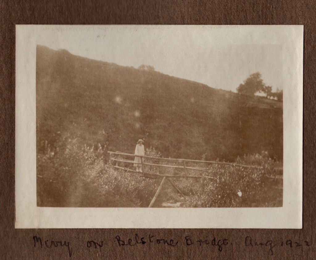
Photos of wooden bridge in the Skaigh valley between Sticklepath and Belstone:
Phyllis Finch album 1920s
Summerhouse (?belonging to Rockside House)
Above and below Minny Storey on Belstone Bridge 1922
STICKLEPATH BRIDGE, sometimes called Taw Bridge, is one of many similar 2 – 3 arched Dartmoor granite bridges with cut waters and pedestrian refuges above. Many are very picturesque, often in a wooded valley with opportunity to fish along the banks and usually somewhere to sit and imbibe refreshments, such as Fingle Bridge:
Unfortunately you cross the bridge as you enter Sticklepath almost without noticing, so it doesn’t have this picturesque appeal, especially as the banks have become overgrown (at least when I last visited) and it is difficult to get a full view from a public footpath.
Sticklepath Bridge early 1900s Chapman (Higher or Southern aspect)
THE PHYSICAL STRUCTURE – Henderson tells us in 1928:
“ A description of the bridge by Green, the county surveyor in 1809, makes its two arches 17 feet in span and the width of the roadway only 14 feet. “This bridge,” he adds, ” being built upon a rock, though rough, is very strong.” A sketch of the bridge and plan made in 1852 shows that the road had been widened to 23 feet. This widening was done on the northern, or lower side, and the cutwater, with its triangular recess, was obliterated. The upper side remained untouched with its two little arches and massive cutwater between them. Thus the bridge remains to-day, and if the widening could be effected on the lower side no harm would be done. The old part of the bridge appears to date from the 17th century, the arches of a nondescript character, as at Fingle Bridge. It is probable, however, that the bridge has been in existence since the 14th century”. ”
Western Times – Friday 24 February 1928 tells us that Mr T.H. Ormston Pearse and Mr J. Pearse submitted objections to the Devon Main Roads Committee their objections to the changing of the pointed arches to rounded arches in the widening of the bridge at Sticklepath. To maintain pointed arches would be more costly and they had been found to be insufficient to take the load of modern traffic. When pressed for an explanation:
“ Colonel Gracey said the bridge had about the weakest form of semi-bastard Gothic arch, and the sub-committee decided there should be an elliptic arch.” The extra cost of at least £300 was a big factor.
Photos above and below taken from the lower side showing that the pedestrian refuge was obliterated pre-1928
This photo also shows the lower section of Bridge House and Cawsand Beacon behind.
However, the Western Times – Friday 20 July 1934, suggests there was more to the story. Mr. Miller explained: “Here the archaeologists claim that the arch is of curious and interesting design. The increased speed and weight of modern traffic had very nearly caused this arch to collapse. The County Engineer averted this by putting in a reinforced concrete saddle, concealed from view, over the arch, which has the effect of relieving the arch of all pressure, of whatever kind. The widening has been carried out in the same design and manner as the ancient bridge, the same arch being carried through the new portion. The same stone has been used as far as possible in the abutments, and where this was not sufficient the moor was scoured for weathered granite. So that it is now impossible to see that any new work has been carried out.”
The village Conservation Area Appraisal 2017 suggests that the present structure is 18th century in origin. It is Grade II listed. Historic England list entry 1171622, National Grid Reference:SX 64354 94028, the description says:
“Road bridge over the River Taw. Probably C18. Snecked blocks of rusticated granite ashlar. 2-span bridge, each a segmental arch rising from vertical abutments. Between the two a pointed cutwater rises into the parapet to provide small refuges each side of the road. The parapet has plain granite coping. No terminal piers.”
Here I am standing in the re-formed pedestrian refuge in 2019. Presumably re-instated in 1928.
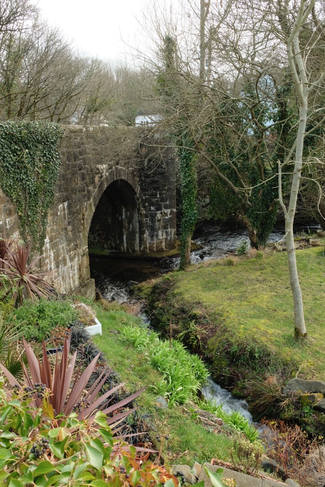
An unusual feature is that the leat joins the river here on the higher side. ( This plays a part in one of the village tragedies so we will come back to this exact spot in February).
This tells us that the old stonework of the bridge is visible underneath, 4m wide, but otherwise no visible medieval remains are visible. (Alexander, j. J. /dcnq/14(1926-1927)115/early bridges). It also says receipts showing repairs were made to the bridge in 1629 are found in Tavistock Churchwardens’ accounts. (These and other sources from the website should be followed up in the future).
We can not know for certain when a bridge was first built here. Perhaps a Ford existed before that and I am aware there is some evidence for use of different routes through the village. We can however surmise that when built the bridge would only have been made as wide as it needed to be. Hence several alterations or re-builds have been required since. Tradition states that the carriage of King George III ( George William Frederick; 4 June 1738 – 29 January 1820, King from 1760) got stuck on our narrow bridge and that one parapet (side wall) had to be knocked down before he could proceed. (WI The Story of Sticklepath). This postcard and of Holne New Bridge illustrates the need for triangular pedestrian refuges and highlights the need for widening as vehicles grew larger and more numerous:
Mid 1950s?
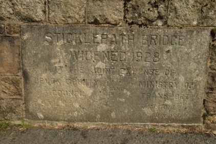
A Commermorative Plaque confirms the later widening in 1928.
Plaque commemorating the Sticklepath Bridge widening 1928 “At the Joint Expense of Devon County Council and Ministry of Transport”. (Photo 2019)
There are two other associated stones of note. The bridge marked the transition from Sampford Courtenay (S.C.) to South Tawton (S.T.) Parish so it is the site of a parish boundary marker. (Photo 2019 showing relationship to commemorative plaque).
The sharp-eyed, walking into the village, will also spot a ‘C’ stone built into the side of Primula House about 75 yards further down the road. Legendary Dartmoor tells us:
“A statute laid down by Henry VIII in 1531 ensured that at least somebody was made responsible for the maintenance of bridges. This statute basically directed that if no landowner, City, Borough, Town, Parish etc. could be proven to be those charged with bridge maintenance then the duty fell upon the County or Shire.”
Such bridges became known as ‘County Bridges’ with maintenance and repair funds coming from taxes levied on local inhabitants.
“The act required that for every bridge, the road over it and for 300ft on either approach should be similarly maintained. In 1841 the Devon magistrates decided that the limits of their responsibility were to be marked by boundstones.” These ‘C Stones’ were about 3 feet high with an incised ‘C’ on one of the faces and placed one on either side of the bridge. (This lasted until 1880 when the newly formed County Councils adopted responsibility.)
‘C’ stone built into the roadside facade of Primula House
Close up of the ‘C’ stone at Primula
WATERSMEET – Before we leave the physical appearance of the area, it is worth noting that I have seen no evidence that Sticklepath Bridge was ever part of the turnpike system (e.g. Burd, E. P., 1936, Okehampton Turnpikes). Watersmeet the house immediately alongside has a diagonal facade reminiscent of Toll houses, however, it is more likely the architect took advantage to maximise its footprint, whilst enabling best visibility for vehicles exiting from the Mill situated behind. (Now private dwellings including Albany House and Mill Cottage). Muriel Bowden suggested that Watersmeet was built in the early 1900s and remembered a sweet shop there run by Miss Harriet Worden, very popular with the children. Later a doctor held surgery in the two front rooms, in competition with Dr Sharp. On the other hand very early photographs do not necessary confirm it was originally built with the diagonal facades and raise the possibility that this was a later alteration perhaps after an accidental damage? I wonder if other early photographs exist? (Interesting also to see on the following photos how the right hand side of the road changes, the magnificent row of elm trees with their shadows in the first postcard disappear, the wall moves back to allow widening and a pavement and later the entrance to Oak Tree Park appears. Notice the chimney on Watersmeet appears and disappears too!)
Watersmeet, just over the bridge with orange tiled roof
Two photos above : Sticklepath Bridge with Watersmeet at the far side and the Mill in behind. Is the Watersmeet facade diagonal?
Early 1900s. The dark house facing us, on left, is Primula (referred to later).
Mid-late 1930s ? Now you see a chimney….
Watersmeet 2019. Now you don’t!
PEOPLE AND EVENTS – A One Place Study aims not only to consider local and social history, but to connect people with places and events. If the stones of our bridge could speak they would have numerous stories to tell. It was of course a frequent meeting place, and not just for romantic couples about to wander along the Taw. The Western Times reports for example Friday 17 November 1865 that Earl Portsmouth’s Hounds meet at Sticklepath Bridge for “The Chase” on 20th. The report on Friday 04 July 1890 says:
“On Sunday week the members of this section of D. Company 4th V.B.D.R. fell in at Taw Bridge for a church parade and marched to the church headed by the band of the company.” “15 band, 35 rank and file.”
The bridge has been crossed by many people of note: Charles I, with his Army in 1644 pursuing the Earl of Essex in Cornwall, availed himself of the courtesy of the bridge, as perhaps his wretched Queen Henrietta had done a few weeks before, when she fled from Exeter to Launceston. Prince Rupert too rode through to quarter his troops in Okehampton, some we know were billeted at Coombehead Farm (the story is told that fearing detection they cut off the head of the cockerel to prevent it crowing and raising the alarm!).
“Many were the coaches that rattled over the bridge when Falmouth became the great Packet Station of the West, and the most famous characters of the 18th century must have been jolted from their slumbers as their postchaises or coaches took the dangerous bend.” (Henderson)
As noted in an earlier blog, in 1805 Lieutenant Lapenotiere set out to from his position off Cape Trafalgar, to deliver his vital dispatches to the Admiralty in Whitehall. His journey across the sea in the HMS Pickle, was beset with trials – rough passage such that the guns had to be thrown overboard, then be-calming. On reaching Falmouth, Lapenotiere would have taken the first possible post-chaise express carriage passing over our village bridge on his way with the news of the triumphant battle of Trafalgar and the death of Nelson.
Much more recently, in 1916, it was at the bridge that our village policeman arrested a man accused of molesting young girls (neither he nor his victims from Sticklepath, the constable had been given a description and correctly identified the man). The Western Times of Friday 07 May 1937 reports a lesser crime:
“STICKLEPATH MAN AND PAYMENT OF FINES. Summonses “for failing to observe a Halt” sign at Sticklepath Bridge on April 18th against Edgar Leslie Gibbs, of The Stores, Sticklepath, were dismissed at Okehampton Sessions Wednesday on payment of costs. Asked to show cause why he had not paid 12s. in respect of fines inflicted him on January 13th he said he had been out of work. At one time he drove a lorry and managed his own business. Now his only income was 2s. a week on a paper round. He was quite prepared to pay 5s. per month.” (1934 Road Traffic Acts and Regulations handbook had introduced the ‘Halt at major road ahead’ sign, precursor of the ‘Stop’ sign).
In 1950 (Western Morning News – Monday 22 May) Douglas St Leger-Gordon wrote about people gathering on the bridge to admire the increasingly rare red squirrel which was visiting it’s nut store close to the bridge daily, and had almost become the village ‘mascot’.
So far I have only had access to secondary sources, but I would be pleased to hear of any access to primary sources or other information.
Unfortunately there are several “Sticklepath” bridges, and it is not clear if all stories relate to ours. The Western Morning News – Wednesday 15 February 1928, points to just such a confusion between what is now known as Grenofen Bridge and our village bridge.
1307 – “BISHOP’S MONEY FOR REPAIRS. Thomas Bytton, cf Exeter, who died in 1307, was prelate renowned for the munificence of his charities. In his will he left a large sum of money for charitable purposes, and desired his executors to journey throughout his Diocese of Devon and Cornwall distributing it as they thought fit. The executors performed their task without sparing themselves, for they journeyed almost to Land’s End. When they returned, in 1310, they made out a long account of what they had distributed. Among other items find the gift of £6 13s. 4d. for the repair, of the Bridge at “Stykelepath” under the “view”or direction of “Robert the Monk there.” This was a large sum for a little bridge, whichever Sticklepath is meant, and we may suppose that Robert the Monk, in his hermitage by the riverside, touched the hearts of the executors by his devotion. Perhaps they had some difficulty in crossing the torrent owing to the ruinous state of the bridge, and Dan Robert, in giving them aid and comfort, was able to point a moral. The incident conjures up a vignette of wayfaring life in the Middle Ages”, and Henderson goes on:
“It is not surprising to find a monk taking charge of the building of a bridge, for in the Middle Ages bridge-building was generally under the auspices of the Church as a work of Christian charity. If the executors had styled him “Frater ” and not “Monachus” one would have regarded Robert as a member of the Order of Pontist Friars, specially formed for the building and maintenance of bridges.”
The Chantry Priest in our village at that time was one Robert de Esse so by my reckoning we have good grounds on which to claim this tale as our own.
ALL COMMENTS ARE WELCOMED.
References / Bibliography (other than those quoted in full above)
The year end is a time for reflection, after the main festivities and whilst we are still so full we can hardly move!
So what is a One Place Study?
Family history + Local history + House histories? Yes
People, places, institutions and events in a historical context. Yes
“Researching the people of a community within the context of the place they live”. (OPS website). Yes
Bringing photos, maps, statistics, stories, primary and secondary sources and analyses together with a view to making them accessible to others? Yes
Bringing different types of information together in an exciting new way? Yes
“investigating a small geographical area in minute detail” (Dr Janet Few) Yes
Potentially serious, careful, accurate and detailed high quality research? Yes
Individual project or group collaboration? Yes
“An intensely personal brand of history” (Dr Janet Few) Yes
A brilliant resource for anyone studying ancestors in that place? Yes
True, but it is so much more. Drawing all this information together, one place studies (OPS) combine different aspects to bring new perspectives. Themes emerge like:
Migration -Why did people move to the place? Where did they go when they left. Why?
War – impact on individuals and the community.
Effects of geography / geology / transport/ access / faith / political or economic state on the population.
The population structure and how groups in society behaved or were treated: the rich, poor, women, children.
What was life really like in this place at different points in time? And so on and on.
For me a huge attraction is the range of possibilities, AND that I can choose what I want to do within it, at a level the suits me, gradually building up. Currently I am at the stage of pulling information together, and working out how on earth to organise it all! With lock down primary sources are fairly limited – just those available via the web.
One HUGE advantage of calling your research a One Place Study and even registering it, is the enthusiastic community of One Placers who encourage and support you.
https://www.one-place-studies.org (Check out the blog summarising great genealogical sites each month, and the numerous videos under ‘resources’)
Dr Janet Few, our amazing Devon genealogist, has written a couple of books about this form of research, most recently ‘Ten Steps to a One-Place Study’ https://thehistoryinterpreter.wordpress.com/publications/. (Full reference below, within the UK contact the author direct for a copy)
The 10 steps, slightly adapted, (apologies Janet), form a useful framework to review my progress.
Step 1 Choose your place and its boundaries:
There are One Placers studying a village, a town, a street, a house, a crescent, a war memorial, a cemetery, a school. No rules here, you can chose any ‘place’ that appeals to you across the world, even a moving target such as a boat! It is worth checking the directory (link above) to check if there is already a study. For me my ‘home village’, my families home for 200 years and where I grew up, the village of Sticklepath was the obvious choice. I have done a little work previously (publications referenced below) mainly since my parents died in 2015, but the flexible format of OPS appeals as a framework. I took a Pharos course on the topic tutored by Janet Few in September 2020 and started from there.
Setting physical boundaries is still a challenge. Sticklepath villagers were included in 3 different Parishes and therefore 3 different census enumerator districts. I am not sure that the current Sticklepath Parish boundaries really reflect the agricultural community of our ancestors. My boundaries remain ‘fluid’ at present.
One key piece of advice was to chose a starting point such as a records source, a date span or a theme. Themes include occupations and local industries, population structure and changes, and those listed above.
Janet warns that it is easy to be enthused by the endless possibilities and not quite get organised. That summarises my 3 months neatly! Covid has of course largely prevented archive visits, even for those close at hand. Living in North Yorkshire, and moving house, with much family and village history still disorganised in multiple boxes, has not helped. However, I have also made some progress and can see some ways forward.
I am working through the Sticklepath section of the Sampford Courtenay Census for 1851 and creating family trees for all the residents on Ancestry, with a physical card index. As a rule of thumb any resident is in the database (this will eventually include those buried in Sticklepath Quaker burying ground). The family trees extend, where I can, to first degree relatives of those residents – parents, siblings, spouse(s) and children. (1851 is the first census with both names and relationships, which helps when creating a pedigree chart!). The aim will be, eventually, to add all the individuals from censuses 1841-1911 and the 1939 register plus many other sources such as directories, Parish registers etc. etc. to create one large database.
My main timeframe is 1770 – 1970. Should time allow I am also attracted to a focus on the decade from 1910 to 1920, leading up to the 1921 census which should be released in January 2022. Not started this yet, but I have booked a Pharos course on researching the 20th century to get me started! (Yes you guessed tutored by none other than JF).
Step 2 Reconstruct
This involves finding past research and books on your place, maps and images. Trying to get an overview of changes over time. Some of this is well outside my comfort zone, but I can chip away at it…
My plan is to use the OPS ‘shared endeavour’ blogs topics planned for next year to help build the picture. These include maps, landmarks, pubs, places of worship, and women in your place.
To be honest I find the idea of using maps both exciting and terrifying. I can get lost going to the next street! However, I have posted a colourful topographical map which I found really interesting and have signed up to learn something more about maps, so watch this space. Pubs – could be challenging, if I tell you my ancestors built a house they called Temperance Cottage…. but I am starting somewhere relatively ‘safe’, Sticklepath Bridge.
Step 3 Populate
Work on a database of residents has already given me a new sense of how inter-related the local villages and villagers were. Once the 1851 census database is completed (perhaps by April?) I will be able to look at overall population statistics and profiles. I am also keen to bring in softer evidence, the stories that have been captured in various places which bring character to the people and families. Such things I am sharing on my (free) WordPress blog and Facebook page.
Step 4 Collect a list of sources and bring the data together. A huge range of potential sources: biographical data from the Parish registers and gravestones; information about dwellings, buildings and institutions such as the school; Organisations such as the temperance movement in the village, scouts, political meetings; Details of events including who was present; Seeking out oral testimony, diaries, letters etc.; newspaper reports, directories; road changes; deeds, wills and probate. (Bearing in mind that many Devon Wills were lost in the bombing of Exeter).
Whilst I have made a start on this I need to both find a way to organise the information and to ensure that I include all possible sources. Once this is progressing I can start Step 5, to Connect, not just people in family groups, but people with places, and people with events. Connect them with a view to analysis (Step 6) and synthesising (Step 7) such as focusing on a time period or theme to draw new conclusions. I hope to use ‘NameandPlace’ software to facilitate this. Step 8 is to Contextualise, look at Sticklepath within historical contexts, comparing the locality to regional and national patterns, perhaps comparing and contrasting with other Devon Villages for example.
As you can see there is a huge amount of potential work here. It should come with a warning about how addictive it quickly becomes!
Step 9 is to disseminate or share findings. For me an early step, with a very steep learning curve, had to be creating a website and ‘blog’. This indeed is my 21st blog post – I feel I have come of age! Still lots to learn about making better blogs (and shorter!) with links. High quality research I feel is for the future. Many people wait until they have more material but for me sharing the information is key, and I am hoping it will enable more people to collaborate or contribute. I have made contact with Sticklepath Heritage Group and did a display and talk a couple of years back. I hope this link can be developed further as there are so many aspects to explore and I have a sense that this is a key moment to capture the early photos and documents and local knowledge of the 19th and 20th centuries before it is lost. We have the technology!
I have also published some thoughts on Blacksmiths in ‘Our Place’ using Sticklepath as my main example, my ‘Christmas Present’ arriving on 24th December, in the form of Destinations the Society newsletter. (Available to members).
I have found others conducting one-place studies have been very encouraging and supportive, willing to share ideas, methodology and good practice. Zoom and Twitter have rather taken over in 2020 from socialising at choir and orchestra during lockdown! So many opportunities online now, many free, to improve your knowledge and skills in family history. Many village history groups on social media willing to offer advice. Others like Devon Family History Society have opened their meetings using Zoom to those of us who could not attend in person – just £12 for the whole year – with many records accessible by members online!
Step 10 is about sharing the enthusiasm, encouraging more people to consider one-place studies. I suppose this is a small step in that direction.
Happy New Year
References
Few, Janet Ten Steps to a One-Place Study Blue Poppy Publishing (2020) 210mm x 148mm paperback 52 pages £5.00 ISBN: 978 1 911438 18 2
Shields, Helen. Walking Sticklepath through the Centuries: Part 1, Devon Family Historian, vol. 170, (2019) pp.20-25.
Shields, Helen. Walking Sticklepath through the Centuries: Part 2, Devon Family Historian, vol. 171, (2019) pp.19-23.
Shields, Helen. Walking Sticklepath through the Centuries: Part 3, Devon Family Historian, vol. 172, (2019) pp.19-23.
https://www.one-place-studies.org (Check out the blog summarising great genealogical sites each month, and the numerous videos under ‘resources’, Destinations newsletter for members which includes those considering starting a One Place Study at some time in the future).