Tomorrow 3rd October 2021 St. Mary’s Church with the Community Church in Sticklepath celebrate the harvest festival. This is a tradition going back many years but perhaps not quite a long as we might think…
Before Henry VIII the harvest was celebrated in churches on 1st August at Lammas – ‘loaf mass’. The wheat harvest safely gathered in, a loaf made from the new flour was used to celebrate Holy Communion.
Harvest Festival in Britain as we have known it owes much to Rev. Robert Hawker of Morwenstow who held a special harvest service in 1843. Harvest has been celebrated in our churches and chapels (also schools and pubs) since, with lavish decoration made from local produce. Chapels and Churches in a locality agreed when the harvest services would be, so they could attend each others. Certainly in my great grandfather Albany Finch’s time, a single hard and essentially inedible loaf was baked in the shape of a wheat sheaf and was taken to the Harvest Festival services across a number of chapels over the weeks. A local preacher, Albany was rather embarrassed when one young relative tried to eat the loaf and he had to take the nibbled version to subsequent chapels!
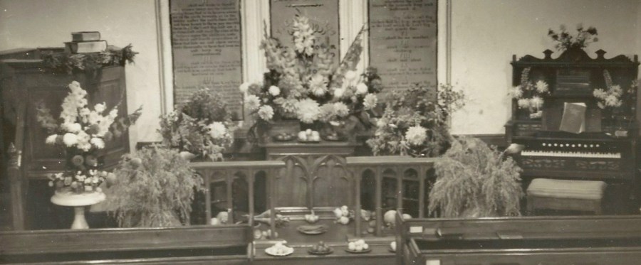
Sticklepath Wesleyan Chapel partly decorated for Harvest Festival. Note the wheat sheaves and the harmonium to accompany the hymns
Hymns were a big feature of the harvest celebrations as I was growing up, ‘Come, ye thankful people, come’, ‘We plough the fields and scatter’ and ‘All things bright and beautiful’. Like all good traditions they have their origins elsewhere. For example, a 17 stanza German poem, with some basis in a psalm, written in 1782 by Mattias Claudius, celebrated Paul Erdmann’s harvest home, thanking both the host and God for their generosity. Translated by Jane Montgomery Campbell, it was shortened and, with a few altered words, made more appropriate for the harvest service, it appeared in ‘Hymns Ancient and Modern’ in 1861 as ‘We Plough the fields and scatter the good seed on the land’.
Certainly in my childhood there was still a large amount of home produce brought to chapel for the celebration – from gardens, farms and kitchens, including of course Bert Stead’s jams. The womenfolk particularly would spend hours arranging flowers and decorating the chapel. As it was a special occasion more folk would come to the service than usual. The following day, Monday, a harvest supper was laid on for all comers. A great social event. The produce was given to the poor and needy or sold at a friendly post-supper auction for charity. Local produce featured both in the displays and the supper. In Yorkshire you find Wensleydale cheese served with the apple pie at Harvest supper, rather than Devonshire’s clotted cream.
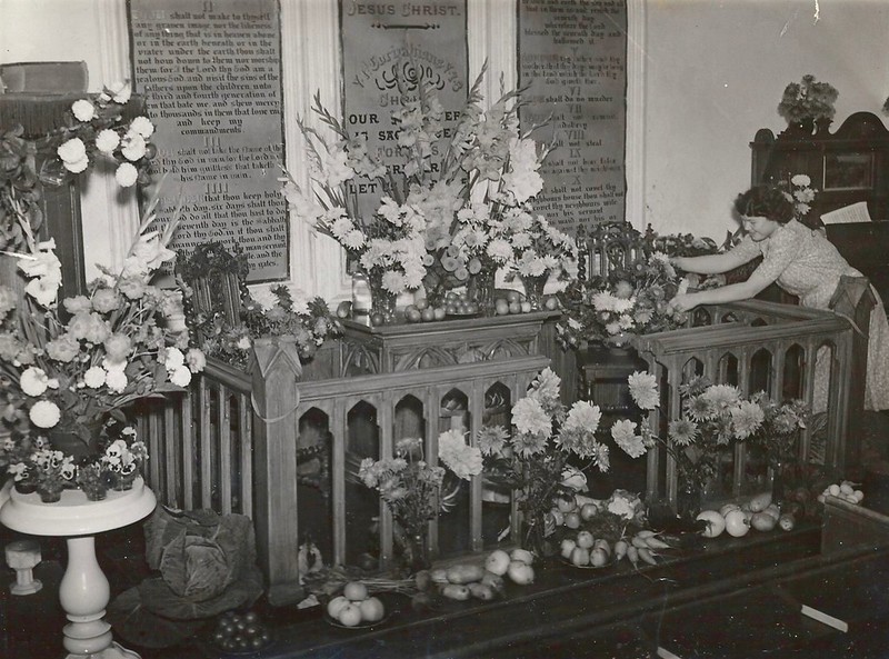
Anne Bowden, Albany Finch’s granddaughter putting some finishing touches to the harvest display Sticklepath Wesleyan Chapel 1954
These days singing traditional hymns is going out of fashion, I am not sure if any of today’s young people will know the words to harvest hymns by heart in their dotage. Now the produce tends to be shop bought non-perishables and collected for food banks or similar charities – not really so very different. Such a sad indictment of our times that in our wealthy nation so many people are still dependant on these sources for their basic necessities.
The Harvest Festival service tomorrow is a great chance to see the fantastic changes made to St Mary’s Church in recent months. It is now a more friendly, comfortable and useable space for the community. I wish I could be there. I wonder if the magnificent harmonium will be accompanying the covid-safe masked singing, or perhaps an electric keyboard?
******************************
ADVANCED NOTICE
Not to be missed! The launch of St Mary’s Interactive Heritage Displays, a Short Service of Dedication and cream teas in the village hall after. Put in in your diary now –
How can we capture Devon’s unique features for someone who has never been? In 1963 W.G.Hoskins (1) described our county as a “land of few villages but many hamlets, even more so of isolated farmsteads, of pasture and livestock, of small fields enclosed in severalty from the beginning or at least since the 14th century, and of wild upland commons.”
Turner describes travelling along Brunel’s Great Western Railway (2). “The train from Taunton to Plymouth snakes along fertile valleys scattered with settlements and tangled with ancient fields and hedgebanks.” “Picture, for example, a great hedge bank in May, draped in primroses, bluebells and campions, snaking alongside a little sunken lane between the spring pastures: nothing evokes the unique spirit of Devon’s landscape more intensely.”
For me it is perhaps those narrow twisty lanes with grass growing along the middle, the hedgerow caressing the car at each side, and the ever present risk of meeting a flock of sheep, that conjures up my childhood view of travelling around Devon. Occasional family days out gave me a wider view – Dartmoor and Exmoor, some of the wildest areas in Southern England; mixed woodland and man made conifer forests; the whole county topped and tailed by rugged coastline, smuggler’s coves and beautiful beaches.
No one would question the statement “Devon has a rich and fascinating rural landscape” (1), moulded in part by the many generations who have lived and worked here. For those how know how to read it, the environment we live in is like a book, telling us about the past. Just as ‘The Old Rectory’ or ‘The Forge’ suggest previous uses of our houses, Devon field names, which often date back to the Middle Ages, give clues as to the features of the land at that time. Developing a deeper understanding of the historic landscape may bring new insights into the lives of our ancestors and the challenges they faced.
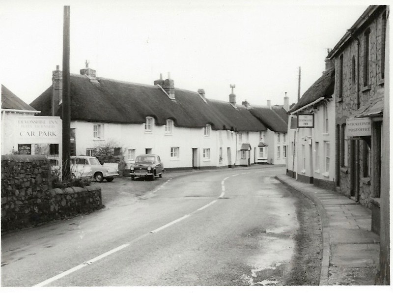
What are the key features of Sticklepath? A typical one-street village in South West England, you can find Sticklepath 20 miles West of Exeter, 3-4 miles East of Okehampton. It has many listed picturesque thatched cottages. Stickle-path is named after the steep, or in Anglo-Saxon ‘staecle’ ancient pack-horse trackway passing through the village. As the road starts to rise by the Ladywell (previously a drinking water supply for the village), the Cleave Valley lane to Belstone branches left. Here was Cleave Mill, and, at one time, further along Skaigh or Ska Valley with its ancient woodlands, was a copper mine with one of the largest water wheels in mainland Britain (70ft diameter).
Thatched Cottages in Sticklepath 1960s
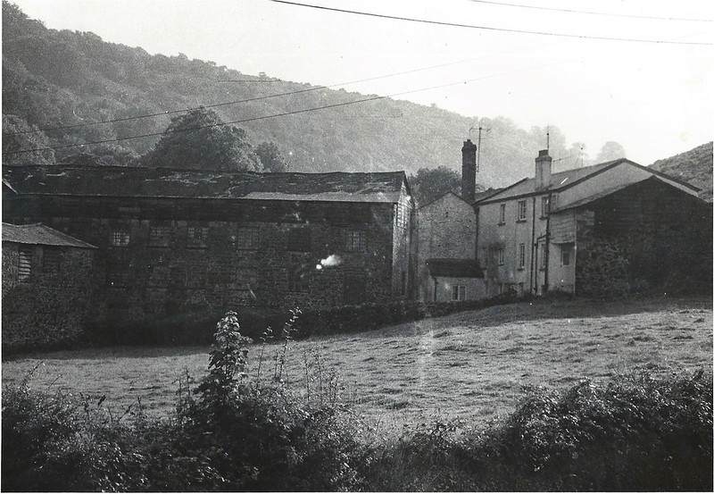
Crucial historically was the diversion of the River Taw to provide water-power. This leat, in a sense, made Sticklepath the village it has become today. At the end of the 18th century Sticklepath had four mills with at least seven waterwheels. Scaw Mill on the South Tawton side of the bridge, closed around 1800. Cleave Mill was an early site, described as Wilmott’s or Curzon’s Mill in 1795. In 1803 it burnt down. The Pearse family bought it in 1810, establishing a highly successful woollen mill, known locally as ‘Factory’. White’s Directory of 1850 records the village as having, ‘…corn, bone and woollen mills.’ Later Cleave Mills were converted to flour and grist (grain with the chaff removed ready for grinding) under Messrs Littlejohns, before conversion to living accomodation.
Cleave Mill prior to conversion to living accommodation
The landscape affects our opportunities for work and links with other places. At the same time human activity impacts and shapes the landscape. Many examples spring to mind – consider the rise and fall of extractive industries during the 19th and 20th centuries, quarrying and mining. Houses were built of local stone, local quarries provided work for the villagers; stone was initially needed for road building, but later as transport links improved, using local building materials became less important. Exhausted and un-economical mines and quarries left their mark, like those seen all around Sticklepath.
Quarry site visible on The Mount, Sticklepath. Taken when the house on the left was being built, demonstrating further change.
How can we begin to analyse the historic environment? It was only in the 1950s that archeologists started to study local ‘ordinary’ landscapes, rather than focusing on buried treasures. W.G.Hoskins was one who has done much to enhance our knowledge of Devon. Advancing technologies now make more of our past ‘visible’. A range of techniques for scanning an area can look at hidden features. The internet makes maps of all sorts available at a touch. Even the satellite views which add so much to our understanding were not easily available to our immediate ancestors. I recall the excitement of owning an aerial photograph at not inconsiderable expense!
Yet all methods have their limitations. We may spot thatch on the roof from an aerial view, but probably not the metal guttering, an unusual feature of many thatched cottages in Sticklepath. An aerial view can not tell us how high the walls and hedges are or even details of what they are made of, let alone what flora and fauna they support. Walking around we see dry stone walls on Dartmoor, where fields were cleared and boundaries made; the riches of the wide hedge banks buzzing with life; the granite walls which are a feature of Sticklepath (especially at the back of properties). A map doesn’t show movement or changes over time, it doesn’t bring sounds, smells and other sensations to our attention. The rolling rhotic or hard ‘R’ that buzzes in our ears immediately tells us “we be in rrreal Dev’n’shurr.” Prevailing winds, temperature and weather, not always visible in themselves, again influence our landscape. Sticklepath folk claim to have a high rainfall due being in a valley, and heavy snows can isolate the village (eg 1963). The seasons and soil affect what grows and which livestock thrive. Amalgamation of many different techniques, illustrating different aspects, and a series of findings over time (maps and photos for example) help us build a more complete picture. The distinctive character of each region and local area has been defined over many years by the particular interaction of farming, industry and other activities.
Being out on a limb, a peninsula, Devon and Cornwall have always seemed a little different to more central areas of England. Many, including Oliver Cromwell, have commented on the different agricultural practices for example. Academics have categorised different landscape types. Oliver Rackham defined 3 broad types of rural landscape – Ancient Countryside, Planned Countryside and Highland Zone (2).
Planned areas, largely re-organised during the 18th and 19th centuries, have a somewhat regular appearance.
Ancient areas appear less organised or standardised.
The Highlands include a mixture of both of these types of landscape as well as heathland and others too.
Most of Devon and Cornwall, like Scotland, fall into the Highland Zone. Geology and geography play a large part here with the wild moorland, and high proportion of coastline with its ports and fishing industries. In addition to the rolling hills and lowland fields that characterise much of Devon, there is much important land use in its orchards, water meadows, and woodlands. The character of the landscape here changes over a short distance. Sticklepath, Belstone, South Tawton and South Zeal villages all have different characters despite lying close together ‘in the shadow’ of Dartmoor’s highest point – Cawsand or Cosdon Beacon. Standing on Cawsand we can see all the types of landscape mentioned above in one view (3).
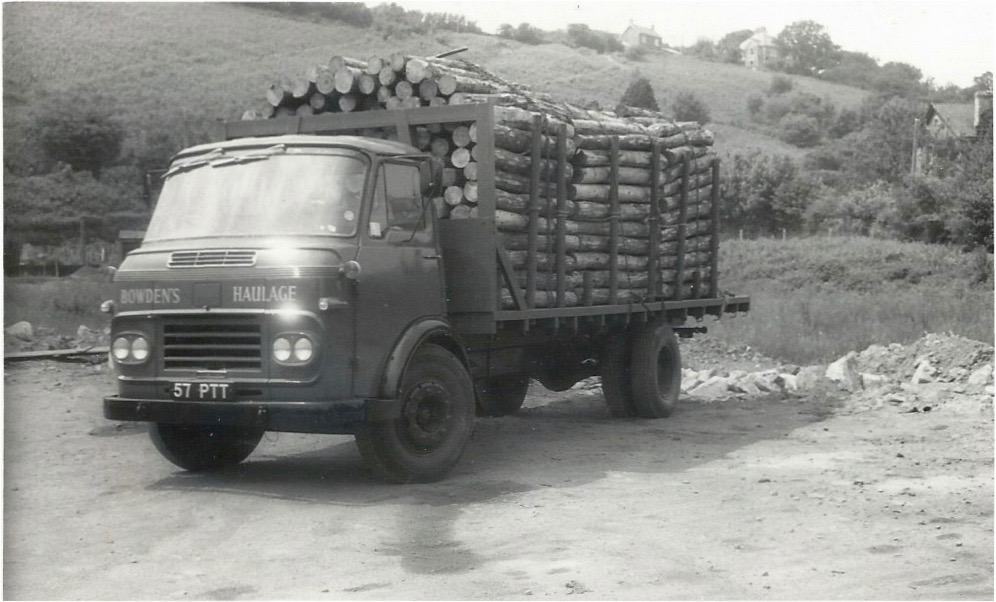
Sticklepath is situated in a largely agricultural area, on the geological ‘Sticklepath Fault’. Many villagers found employment on farms and in the mines and quarries. Greenhill and Ramsley mines employed Sticklepath men and produced high grade copper ore from at least the mid 19th century into the early 20th century. Encouraging tourism has also been part of the village ethos from at least 1900, with an emphasis on the ‘clean air’ benefitting health. The Forestry Commission from 1919, established conifer plantations across the county, providing work for Bowden’s Haulage, a Sticklepath firm established in the 20th century, which carried pit props to Wales and logs to St Anne’s board mills in Bristol, for cardboard manufacture.
Bowden’s lorry carrying Forestry Commission timber. Note the steep path, just visible, up the Mount behind.
Settlement patterns changed over time. Documents from the 13th century refer to the settlement at Sticklepath. Neighbouring South Zeal’s Burgage plots were planned from scratch but Sticklepath likely involved re-ordering or extension of an established settlement. Such a field structure is typical of 12th – 14th century Devon villages. Each house having a strip of land from which the family made or supplemented their income.
Aerial view North of the village centre of Common Field strip or Burgage plots, one sub-divided into allotments.
Sticklepath’s main street runs West to East. To the South the river and moorland are just one field width away. For many Parishes the Manor shaped the settlement. There was no manor or squire for Sticklepath, but Hall’s or Hole’s Tenement attained some quasi-manorial status. A legal case of 1565 mentions ‘John Dymocke, Gent; and Mary his wife of the Manor of Sticklepath’ (Fines Devon, 7 and 8 Eliz: Michm) and many deeds refer to property in the ‘reputed manor of Sticklepath’. That quasi-manorial status was lost long ago. (4)
St Mary’s
Sticklepath Wesleyan Methodist Chapel
Many of our landmarks have already been written about. St Mary’s Church, the Wesleyan Chapel, Sticklepath bridge, the LadyWell, the Village Hall, the Quaker burying ground and the mysteries of our standing stones. All an important part of who we are, where we came from, and the meaningfulness of our unique village.
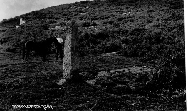
The “Honest Man” Standing stone with The Mount behind. Chapman Postcard.
Changes to the environment may occur gradually or stepwise; a continuum punctuated by jolts, the results of a complexity of events and circumstances such as new laws, war, economic booms or downturns, new developments. The Industrial Revolution and the Enclosure Acts brought change for many areas, new modes of transport, or the coming of piped water or electricity too.
There were at least three farms within Sticklepath village, Steddaford, Sunnyside and Hall’s Tenement (now the Taw River Inn). Agriculture is pushed back as a settlement grows, still close by but not so obvious now as we pass along the street. Long gone is the sight of farmers bringing their sheep down from the moor, taking grain to the mills, or wool to the ‘factory’.
Part of Steddeford’s Farm, now Oak Tree Park
The Millennium Seat Oak Tree Park
Oak Tree Park
We have seen a decrease in small farms, and extensive housebuilding as individuals and nuclear families have each come to expect their own homes. Sticklepath has houses in Grove Meadow and the Oaktree Park estate, both built since 1970 and there has been “in-filling” along the road, making a barrier for pedestrians in the village who would like to admire the countryside, reducing its feel as a rural village. If, for instance the chapel garden is ever built on, then there would be little or no remaining view across to open fields in the centre of the village.
Grove Meadow Before and….
After: Bottom right corner we see Grove Meadow houses built, St Mary’s behind.
In our own lifetime there has been a huge increase in motorways and vehicles. A dual carriageway bypassing Sticklepath since 1987 initially reduced traffic through the village. The presence of large numbers of parked cars at all times and many signs, poles and wires, detract greatly from the ‘rural idyll’. Perhaps the appearance will benefit again as, for example, telephone landlines become defunct in the coming years. Appearance was felt to be important in 1938:
BEAUTIFYING A VILLAGE Unsightly telegraph poles are to be removed at Sticklepath… Workmen are now relaying the lines underground. (Western Morning News 30 March 1938).
Time will tell whether Covid has made a step change in the way we live our lives, where we work, how we do our shopping, perhaps having a lasting effect on our priorities and work opportunities.
As Sticklepath sits at the northern edge of Dartmoor we turn now to the moor.
One might look at Dartmoor on a cold grey day and see a windswept barren area but in addition to its supplies of stone, especially granite, we know the livestock, peat cutters and whortleberry pickers have all benefitted from its riches as well as those on Army manoeuvres, and many more. In addition to picnics and rambles, my personal memories include walking out to a celebration of Easter at sunrise on Yes Tor, not an insignificant pilgrimage for a child!
Dartmoor became a National Park in October 1973, including Sticklepath from 1994. The informative 2017 Sticklepath Conservation Area Character Appraisal (5) mentions its boundaries being extended to take in more of Sticklepath.
Despite being adjacent to the moor, being part of the. more distant Sampford Courtenay Parish meant Sticklepath had very little Common land. It was only that part of The Mount lying between the old and new road, known as ‘Wooders’, and ‘Sticklepath Moor’, now lying between the main road and Willey lane, where traditionally any villagers could graze animals. Some deeds specify the right. In 1766 this ‘common of pasture’ was granted to the holding named Reynolds (now Sunnyside house) for ‘two cows, one horse, two pigs and one little pig’.
Traditions include collecting and using peat for fuel, and ‘beating the bounds’, where villagers walk the Parish boundary. Swaling, the controversial burning of vegetation to maintain common grazing areas was common until 50 or 60 years ago. Vegetation on the Mount in Sticklepath, largely bracken, heath and gorse in my childhood, has gained height and variety in the last 50 years. Not so useful for grazing animals now. Douglas and Ruth St Leger Gordon, who lived at Steddaford’s in Sticklepath, wrote extensively about Dartmoor and its folklore and customs.
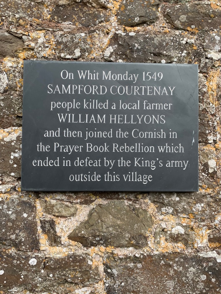
Historical events also mark our landscapes and are important to those who know about them. Such moments in history are almost a fingerprint, or in some cases a pock mark, that shaped our identity. The value of a place is not just in the visible but our emotions and its social and cultural associations play a part too. Our Parish was the site of the start of the Prayerbook Rebellion, with about 7000 men involved.
The steps where William Hellyons was killed in Sampford Courtenay village.
Memorial Plaque
On Whitsunday 1549 the prayer book in English was introduced. On Whitmonday the Parishioners of Sampford Courtenay forced their priest to revert to the latin format. At the next service Justices came to enforce the change. An argument ensued which ended in William Hellyons, a proponent of the change, being killed on the church house steps, sparking the revolt.
Perhaps more significant for Sticklepath village itself were the Wesleys’ visits to the Quakers, a dominant group in the village in the mid-18th century. The flag pole and ‘White Rock’ up on the mount looking down over Sticklepath mark the place John Wesley is said to have preached. The rock continues to be painted and the anniversaries are marked. Wesleyan Methodism was well supported in the village throughout the 19th century and until the late 20th century. The separation from Sampford Courtenay and establishment of Sticklepath Parish in the 1980s was another key moment.
Looking forward: Knowledge of the landscape also helps planners and conservationists consider how best to manage and enhance its future whilst preserving its heritage. In these days of increased leisure, paths previously necessary for workers and pack horses might find a new meaning. The recently launched Archangel Way (July 2021) , a 35 mile long Pilgrimage walk from St Michael Church on top of Brentor to St Michael the Archangel church in Chagford, is one example. Longer ago I recall the launch of the Tarka Trail in 1987, the Southern loop of which crosses the Taw behind the Foundry in Sticklepath. A very pleasant walk can be found from the bridge at one end of the village, along the far side of the Taw, returning along the valley road from Belstone for example. Wildlife too, such as the hares trapped 120 years ago to feed the hungry poor, now attract tourists and time spent on Dartmoor in a natural environment has been given a new value in helping our mental well-being.
The concept of #OnePlaceEnvironment is complex incorporating not just the landscape but many aspects, such as the social and political context, which have not been touched on here. Herring (3) says
“The definition of landscape developed for the European Landscape Convention (in force in the UK since March 2007) catches the more democratic and cognitive approaches of historic landscape characterisation. That is to say it is cognitive pertaining to perception, memory, judgement and reasoning: ‘‘An area, as perceived by people, whose character is the result of the action and interaction of natural and/ or human factors’’ (Council of Europe, 2000; Fairclough, 2002).”
Just as the history of a battle is usually written by the victors, historic evidence is biased, usually more influenced by the higher social classes. These ‘One-Place’ environment ramblings are a subjective, personal and incomplete assessment, coloured greatly by my own experiences, memory and knowledge. As this One-Place Study progresses I hope to enrich and deepen that understanding of the historic environment.
Bibliography.
Provincial England: Essays in Social and Economic History by WG Hoskins 1963. London, MacMillan & Co.Ltd.
Ancient Country: The Historical Character of Rural. Devon by Sam Turner. Devon Archaeological Society Occasional Paper 20. 2007
Framing Perceptions of the HistoricLandscape: Historic LandscapeCharacterisation (HLC) and HistoricLand-Use Assessment (HLA) Peter Charles Herring Scottish Geographical Journal Vol. 125, No. 1, 61–77, March 2009
Secondary sources used primarily: South Tawton & South Zeal – with Sticklepath 1000 years beneath the beacon. Roy and Ursula Radford 2000. Halsgrove. (Note: Examination of primary sources is a long term aim. Manorial records for Sticklepath are at Devon archive. King’s College, landowners for much of the area, have further records in Cambridge.)
We started last time with a burial, William John Labdon in Sticklepath. Will’s father, Joseph as a FAN (friend, associate and/or neighbour) of #Sticklepath #One-Place Study, warrants investigation in his own right.
Introduction
Joseph Labdon was born on 22 August 1842 in Bradninch, Devon, youngest son of William, aged 47 and his wife Jane (born Stoyal) age 37. He married Susan Ireland in Wellington, Somerset on 1 May 1866 and they had 11 children together. At least 3 died during childhood. He became a Police Constable in Bratton Clovelly, Chillaton and then in South Zeal. 18 months after Susan died he married Elizabeth Knapman on 25 July 1889. In his later years he was a carpenter and undertaker in South Tawton. Joseph died in March 1915 at the age of 72.
I use Ancestry to create the family tree for each resident and managed to make contact with several members of the #Labdon Family through the website. I was delighted when they generously shared their research and some photos and scans. Many thanks especially to Patrick Mitchell for information about Susan Labdon’s death and all the images in this post, which he has kindly allowed me to use. Thanks too to the British Newspaper Archive where I accessed the newspaper items (July 2021).
PC Labdon. Photo supplied by Patrick Mitchell
Joseph’s early life and career
In 1851, aged 8, Joseph is living at Higher Trinity, Bradninch, with his mother Jane, father William, a carpenter, and 3 older siblings.
By the age of 18 he and his brother were journeyman carpenters living with their parents. Mother is dress-making and father now calls himself a Master carpenter. (Journeyman suggests they had completed an apprenticeship or training within the family and are now gaining experience. Literally day worker, from the French ‘jour’). William’s grand-daughter, likely Joseph’s niece, Sophia aged 8, is staying with them.
We don’t know how Joseph, aged 23, met Susan. He was still living in Bradninch and working as a carpenter at the time they married. One of the witnesses was a Sophia Labdon, who may have been his niece at age 13 it is more likely his older sister of the same name. The family moved around Devon quite a bit. How did they come to move to our villages?
Between 1866 and 1871 Joseph trained as a police constable, and by 1871 he was appointed Constable in Bratton Clovelly. He probably trained in Exeter but their first two children: Mary Sophia aged 3 and William John aged 2 were born in Cullompton. This suggests the family may have been living there at the time. There were certainly Labdon relatives in Cullompton who may have employed him. The youngest child on the 1871 census, aged 8 months, was born in Bradninch. Could they have been staying with his parents at the time?
By 1881 the family are living in Chillaton, Milton Abbot Parish, perhaps in a police house, with several more children.
Daughter Elizabeth Jane died in 1881, this death was registered in Okehampton, so they may have already been in South Zeal. Son William John, subject of the last blog post, died in March 1882, when we know the family were living in South Zeal.
The migration path has been mapped by an @FACHRS project. (Scroll down to bottom of link page.) Many thanks to researcher Martin Allen. Amazing what you can find online!
The Devon Constabulary
For many years, up until the mid-19th century, in rural areas Parish constables were appointed usually as volunteers. The County Police Acts of 1839 and 1840 initiated change and in 1856 Devon Constabulary was finally formed. Initial recruits were largely Devon men who had joined the Bristol City Police but now jumped at the chance to return to their home county.
In February 1857. the Constabulary consisted of 108 Constables, 12 Sergeants, 2 Inspectors and 4 Super-intendants all under the watchful eye of Gerald de Courcy Hamilton. Classroom tuition for new recruits was provided at Exeter Ragged School, with practical swordsmanship skills taught at Exeter Castle. Uniforms by Messrs Hibberd & Son, army contractors in London. The Constabulary gradually absorbed the boroughs and areas of Devon, including Okehampton in 1860 and Bradninch in 1866. Joseph Labdon must have completed training at some point between 1866 and 1871.
In 1871 constables wore a low brimmed hat with chin strap and long frock coats. They often carried their essentials in haversacks whilst they walked their long beats. A truncheon (not a sword) hung from their belt. From about 1879 the new ‘Pickelhaub’ helmets were used, but by 1903 these were deemed too similar to the Prussian military helmet, and the Boar War bush hat (‘slouch hat’) was brought into use. (See photos)
The old Parish Constables came from within the community but the new Devon Constabulary moved their Constables frequently to avoid too much fraternisation. This largely explains his moves. They were paid and often a specific ‘Police House’ was provided. In Sticklepath there was a Police House near the Bridge until Pixie Nook, on the way towards Okehampton was specially built.
PC Joseph Labdon – the Policeman
Policemen were required to attend court, and petty sessions were often reported in the newspaper. For example, several times PC Labdon arrested John Martin, landlord of the Devonshire Inn, Sticklepath for drunkenness and disorderly behaviour. In 1882 John Martin and William Mugridge, a farmer, were summoned for assaulting P.C.Labdon whilst in the execution of his duty, a quarrel arising when they were drinking after hours (Express and Echo 2 Nov 1882).
John Martin didn’t change his ways, he was summoned for being drunk on the highway in Sticklepath in April 1883 by PC Labdon. We find him in court yet again in August 1883: at Crockernwell Petty Sessions PC Labdon summoned John Martin, landlord of the Devonshire Inn Sticklepath for being drunk on licensed premises at South Zeal – he was fined £1 and costs. In the same session PC Labdon confirmed the state of a sheep which had been ill-treated by a farmer’s son of South Tawton. On another occasion he was the first policeman to a suicide. It was not an easy job.
Torquay Times, and South Devon Advertiser – Friday 06 October 1882 SAVAGE ASSAULT ON THE POLICE
“Jas. Glanville, a mason, of South Zeal, was brought up in custody charged on a warrant with assaulting Constable Joseph Labdon, whilst in the execution of his duty at South Zeal. Whilst the constable was on duty he heard a disturbance, and some one remarked, “Here comes the — let him have it.” The prisoner was very violent, tearing the constables uniform and scratching his face. He was remanded in custody till Saturday.”
He was also involved in the crime scene investigation when Ellen Gillard was assaulted in 1884.
Later Careerand personal life
Joseph stopped being a policeman at some point during the mid-1880s. No evidence has been found to suggest he qualified for a pension or that there was any specific incident leading to his change of career. His father William died in 1881. As the youngest son perhaps Joseph inherited some tools and well seasoned wood from his father. (I have not found any evidence of a will.). We have seen Joseph was assaulted at work twice during 1882, I wonder if this combined with the family deaths noted above and, perhaps most importantly, his wife’s illness, led him to make a change in his career. Susan died of long standing heart disease and dropsy for 4 months. Joseph described himself as a retired police constable when he register her death in December 1887.
We can follow Joseph in the census, and the newspaper gives us some information about both his business and personal matters. In 1891 the family are living in South Tawton, at Shelly House. Joseph describes himself as a carpenter and builder. Son Samuel, also a carpenter, is living with them, aged 20. Joseph is on the local villages Cottager’s Show committee that year, and we can see that he wins prizes for his parsnips, cucumbers and other vegetables in different years. We can also find him attending political meetings, for example for the conservatives in South Zeal 1895 (Exeter and Plymouth Gazette July 9th).
Letterhead Scan provided by Patrick Mitchell
In 1898 Okehampton District Council accepted the tender by J. Labdon (South Tawton) to supply posts for staking stone depots. (Western Times May 2nd). By 1901 Joseph, carpenter, and his wife Elizabeth live alone in a cottage in South Tawton village. Richard Knapman, blacksmith is their immediate neighbour. (The relationship if any to Elizabeth nee Knapman is unknown.) The addresses are not given, but they are on the same page as the houses by Sticklepath Bridge so may have been close to Sticklepath, part of which was in South Tawton Parish. The neighbours may not have been on the best of terms.
East & South Devon Advertiser on Saturday 06 June 1896 reported the Crockernwell Petty Sessions:
” Richard Knapman, blacksmith, of Southtawton, was fined 20s. and costs for assaulting Joseph Labdon of the same place. On the Ist May the parties had an altercation on parish matters and politics, and the blacksmith “swinging his arm round,” the complainant’s teeth were knocked out.”
The Western Times reports 25 June 1901 that
“Messrs. Burd, Pearse and Mr Prickman, solicitors, Okehampton, made an application on behalf of Mr. Labdon, the undertaker, for the payment of a sum of £1 4s, being the cost incurred in the burial of a pauper. It was alleged that the relieving officer had given Mr. Labdon instructions to make coffins without waiting for official orders.”
This was not held against him as the Western Times 17 March 1905 tells us that Okehampton Board of Guardians accepted a tender for coffins from J. Labdon for South Tawton.
Joseph Labdon in South Tawton. Photo supplied by Patrick Mitchell
In 1911, at aged 68, Joseph described himself as a carpenter and undertaker. Several funeral reports from the early 1900s name him as the undertaker. In 1911, he and Elizabeth had been married 23 years and had a live in servant and general labourer, Ernest Gillard aged 14. Joseph died in 1915.
Joseph Labdon (with stick) at his daughter Millicant Rhoda’s wedding to Richard Dimond Mitchell 1909. Photo supplied by Patrick Mitchell.
Please let me know if you can add any further information for this family or any others with links to Sticklepath. Investigating a number of different families I may get some information wrong, please do let me know.
All comments welcome! shields_h_f@hotmail.com Thank you.
COMMENT FROM Patrick Mitchell: I think Susan Ireland met Joseph Labdon as a result of her brother Thomas being stationed at Bradninch in the 1860s. He was a railway policeman on the Bristol and Exeter Railway, who later moved to Bedminster near Bristol as a signalman.