How can we capture Devon’s unique features for someone who has never been? In 1963 W.G.Hoskins (1) described our county as a “land of few villages but many hamlets, even more so of isolated farmsteads, of pasture and livestock, of small fields enclosed in severalty from the beginning or at least since the 14th century, and of wild upland commons.”
Turner describes travelling along Brunel’s Great Western Railway (2). “The train from Taunton to Plymouth snakes along fertile valleys scattered with settlements and tangled with ancient fields and hedgebanks.” “Picture, for example, a great hedge bank in May, draped in primroses, bluebells and campions, snaking alongside a little sunken lane between the spring pastures: nothing evokes the unique spirit of Devon’s landscape more intensely.”
For me it is perhaps those narrow twisty lanes with grass growing along the middle, the hedgerow caressing the car at each side, and the ever present risk of meeting a flock of sheep, that conjures up my childhood view of travelling around Devon. Occasional family days out gave me a wider view – Dartmoor and Exmoor, some of the wildest areas in Southern England; mixed woodland and man made conifer forests; the whole county topped and tailed by rugged coastline, smuggler’s coves and beautiful beaches.
No one would question the statement “Devon has a rich and fascinating rural landscape” (1), moulded in part by the many generations who have lived and worked here. For those how know how to read it, the environment we live in is like a book, telling us about the past. Just as ‘The Old Rectory’ or ‘The Forge’ suggest previous uses of our houses, Devon field names, which often date back to the Middle Ages, give clues as to the features of the land at that time. Developing a deeper understanding of the historic landscape may bring new insights into the lives of our ancestors and the challenges they faced.
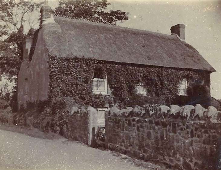
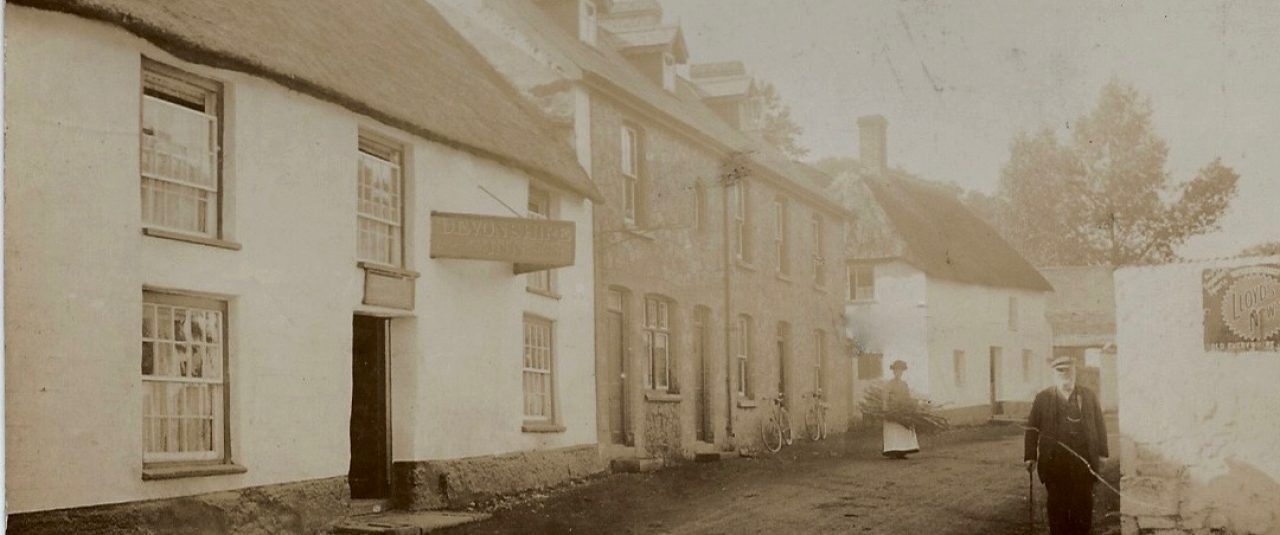
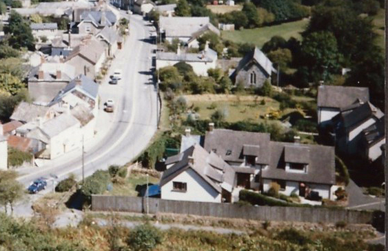
What are the key features of Sticklepath? A typical one-street village in South West England, you can find Sticklepath 20 miles West of Exeter, 3-4 miles East of Okehampton. It has many listed picturesque thatched cottages. Stickle-path is named after the steep, or in Anglo-Saxon ‘staecle’ ancient pack-horse trackway passing through the village. As the road starts to rise by the Ladywell (previously a drinking water supply for the village), the Cleave Valley lane to Belstone branches left. Here was Cleave Mill, and, at one time, further along Skaigh or Ska Valley with its ancient woodlands, was a copper mine with one of the largest water wheels in mainland Britain (70ft diameter).
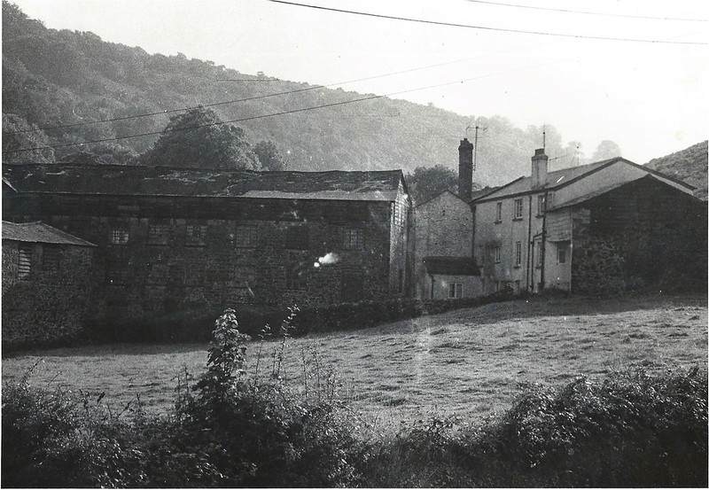
Crucial historically was the diversion of the River Taw to provide water-power. This leat, in a sense, made Sticklepath the village it has become today. At the end of the 18th century Sticklepath had four mills with at least seven waterwheels. Scaw Mill on the South Tawton side of the bridge, closed around 1800. Cleave Mill was an early site, described as Wilmott’s or Curzon’s Mill in 1795. In 1803 it burnt down. The Pearse family bought it in 1810, establishing a highly successful woollen mill, known locally as ‘Factory’. White’s Directory of 1850 records the village as having, ‘…corn, bone and woollen mills.’ Later Cleave Mills were converted to flour and grist (grain with the chaff removed ready for grinding) under Messrs Littlejohns, before conversion to living accomodation.
The landscape affects our opportunities for work and links with other places. At the same time human activity impacts and shapes the landscape. Many examples spring to mind – consider the rise and fall of extractive industries during the 19th and 20th centuries, quarrying and mining. Houses were built of local stone, local quarries provided work for the villagers; stone was initially needed for road building, but later as transport links improved, using local building materials became less important. Exhausted and un-economical mines and quarries left their mark, like those seen all around Sticklepath.

How can we begin to analyse the historic environment? It was only in the 1950s that archeologists started to study local ‘ordinary’ landscapes, rather than focusing on buried treasures. W.G.Hoskins was one who has done much to enhance our knowledge of Devon. Advancing technologies now make more of our past ‘visible’. A range of techniques for scanning an area can look at hidden features. The internet makes maps of all sorts available at a touch. Even the satellite views which add so much to our understanding were not easily available to our immediate ancestors. I recall the excitement of owning an aerial photograph at not inconsiderable expense!
Yet all methods have their limitations. We may spot thatch on the roof from an aerial view, but probably not the metal guttering, an unusual feature of many thatched cottages in Sticklepath. An aerial view can not tell us how high the walls and hedges are or even details of what they are made of, let alone what flora and fauna they support. Walking around we see dry stone walls on Dartmoor, where fields were cleared and boundaries made; the riches of the wide hedge banks buzzing with life; the granite walls which are a feature of Sticklepath (especially at the back of properties). A map doesn’t show movement or changes over time, it doesn’t bring sounds, smells and other sensations to our attention. The rolling rhotic or hard ‘R’ that buzzes in our ears immediately tells us “we be in rrreal Dev’n’shurr.” Prevailing winds, temperature and weather, not always visible in themselves, again influence our landscape. Sticklepath folk claim to have a high rainfall due being in a valley, and heavy snows can isolate the village (eg 1963). The seasons and soil affect what grows and which livestock thrive. Amalgamation of many different techniques, illustrating different aspects, and a series of findings over time (maps and photos for example) help us build a more complete picture. The distinctive character of each region and local area has been defined over many years by the particular interaction of farming, industry and other activities.
Being out on a limb, a peninsula, Devon and Cornwall have always seemed a little different to more central areas of England. Many, including Oliver Cromwell, have commented on the different agricultural practices for example. Academics have categorised different landscape types. Oliver Rackham defined 3 broad types of rural landscape – Ancient Countryside, Planned Countryside and Highland Zone (2).
- Planned areas, largely re-organised during the 18th and 19th centuries, have a somewhat regular appearance.
- Ancient areas appear less organised or standardised.
- The Highlands include a mixture of both of these types of landscape as well as heathland and others too.
Most of Devon and Cornwall, like Scotland, fall into the Highland Zone. Geology and geography play a large part here with the wild moorland, and high proportion of coastline with its ports and fishing industries. In addition to the rolling hills and lowland fields that characterise much of Devon, there is much important land use in its orchards, water meadows, and woodlands. The character of the landscape here changes over a short distance. Sticklepath, Belstone, South Tawton and South Zeal villages all have different characters despite lying close together ‘in the shadow’ of Dartmoor’s highest point – Cawsand or Cosdon Beacon. Standing on Cawsand we can see all the types of landscape mentioned above in one view (3).
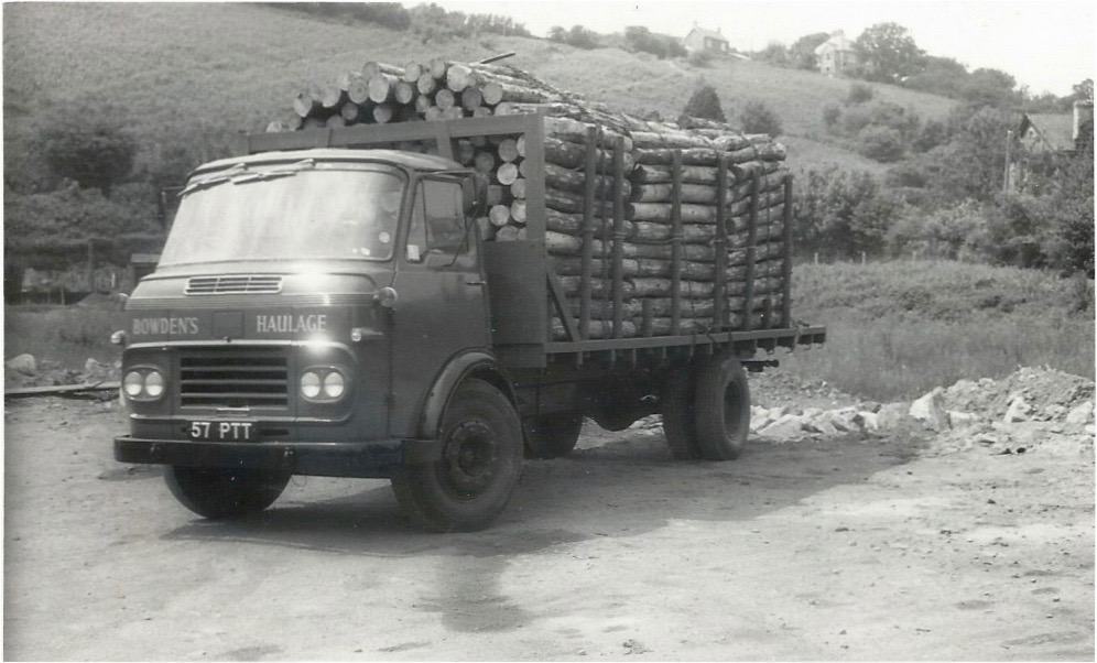
Sticklepath is situated in a largely agricultural area, on the geological ‘Sticklepath Fault’. Many villagers found employment on farms and in the mines and quarries. Greenhill and Ramsley mines employed Sticklepath men and produced high grade copper ore from at least the mid 19th century into the early 20th century. Encouraging tourism has also been part of the village ethos from at least 1900, with an emphasis on the ‘clean air’ benefitting health. The Forestry Commission from 1919, established conifer plantations across the county, providing work for Bowden’s Haulage, a Sticklepath firm established in the 20th century, which carried pit props to Wales and logs to St Anne’s board mills in Bristol, for cardboard manufacture.
Settlement patterns changed over time. Documents from the 13th century refer to the settlement at Sticklepath. Neighbouring South Zeal’s Burgage plots were planned from scratch but Sticklepath likely involved re-ordering or extension of an established settlement. Such a field structure is typical of 12th – 14th century Devon villages. Each house having a strip of land from which the family made or supplemented their income.

Sticklepath’s main street runs West to East. To the South the river and moorland are just one field width away. For many Parishes the Manor shaped the settlement. There was no manor or squire for Sticklepath, but Hall’s or Hole’s Tenement attained some quasi-manorial status. A legal case of 1565 mentions ‘John Dymocke, Gent; and Mary his wife of the Manor of Sticklepath’ (Fines Devon, 7 and 8 Eliz: Michm) and many deeds refer to property in the ‘reputed manor of Sticklepath’. That quasi-manorial status was lost long ago. (4)
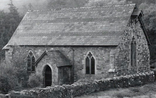

Many of our landmarks have already been written about. St Mary’s Church, the Wesleyan Chapel, Sticklepath bridge, the LadyWell, the Village Hall, the Quaker burying ground and the mysteries of our standing stones. All an important part of who we are, where we came from, and the meaningfulness of our unique village.
Changes to the environment may occur gradually or stepwise; a continuum punctuated by jolts, the results of a complexity of events and circumstances such as new laws, war, economic booms or downturns, new developments. The Industrial Revolution and the Enclosure Acts brought change for many areas, new modes of transport, or the coming of piped water or electricity too.
There were at least three farms within Sticklepath village, Steddaford, Sunnyside and Hall’s Tenement (now the Taw River Inn). Agriculture is pushed back as a settlement grows, still close by but not so obvious now as we pass along the street. Long gone is the sight of farmers bringing their sheep down from the moor, taking grain to the mills, or wool to the ‘factory’.

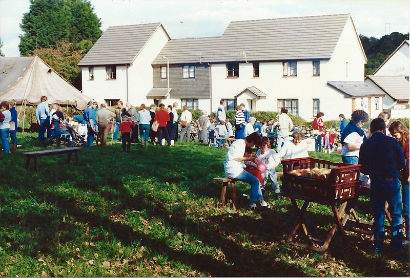
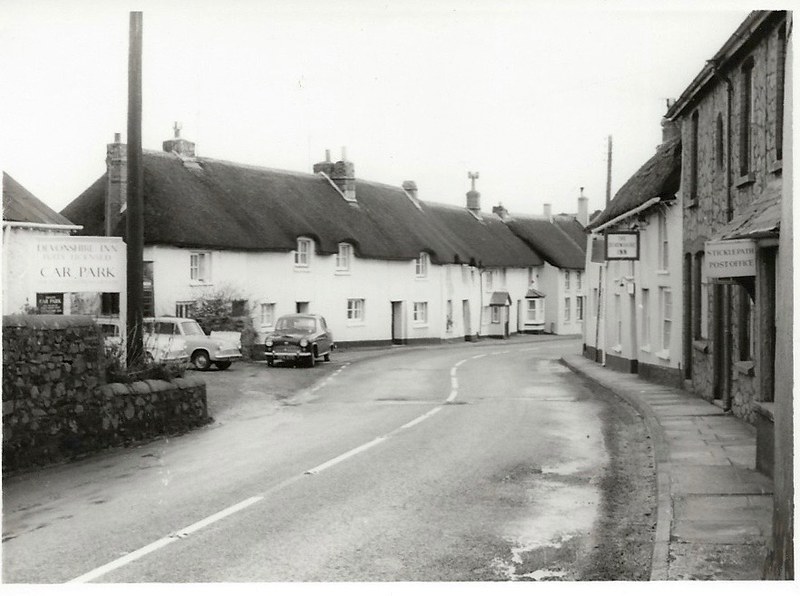
We have seen a decrease in small farms, and extensive housebuilding as individuals and nuclear families have each come to expect their own homes. Sticklepath has houses in Grove Meadow and the Oaktree Park estate, both built since 1970 and there has been “in-filling” along the road, making a barrier for pedestrians in the village who would like to admire the countryside, reducing its feel as a rural village. If, for instance the chapel garden is ever built on, then there would be little or no remaining view across to open fields in the centre of the village.

In our own lifetime there has been a huge increase in motorways and vehicles. A dual carriageway bypassing Sticklepath since 1987 initially reduced traffic through the village. The presence of large numbers of parked cars at all times and many signs, poles and wires, detract greatly from the ‘rural idyll’. Perhaps the appearance will benefit again as, for example, telephone landlines become defunct in the coming years. Appearance was felt to be important in 1938:

Time will tell whether Covid has made a step change in the way we live our lives, where we work, how we do our shopping, perhaps having a lasting effect on our priorities and work opportunities.
As Sticklepath sits at the northern edge of Dartmoor we turn now to the moor.
One might look at Dartmoor on a cold grey day and see a windswept barren area but in addition to its supplies of stone, especially granite, we know the livestock, peat cutters and whortleberry pickers have all benefitted from its riches as well as those on Army manoeuvres, and many more. In addition to picnics and rambles, my personal memories include walking out to a celebration of Easter at sunrise on Yes Tor, not an insignificant pilgrimage for a child!
Dartmoor became a National Park in October 1973, including Sticklepath from 1994. The informative 2017 Sticklepath Conservation Area Character Appraisal (5) mentions its boundaries being extended to take in more of Sticklepath.
Despite being adjacent to the moor, being part of the. more distant Sampford Courtenay Parish meant Sticklepath had very little Common land. It was only that part of The Mount lying between the old and new road, known as ‘Wooders’, and ‘Sticklepath Moor’, now lying between the main road and Willey lane, where traditionally any villagers could graze animals. Some deeds specify the right. In 1766 this ‘common of pasture’ was granted to the holding named Reynolds (now Sunnyside house) for ‘two cows, one horse, two pigs and one little pig’.
Traditions include collecting and using peat for fuel, and ‘beating the bounds’, where villagers walk the Parish boundary. Swaling, the controversial burning of vegetation to maintain common grazing areas was common until 50 or 60 years ago. Vegetation on the Mount in Sticklepath, largely bracken, heath and gorse in my childhood, has gained height and variety in the last 50 years. Not so useful for grazing animals now. Douglas and Ruth St Leger Gordon, who lived at Steddaford’s in Sticklepath, wrote extensively about Dartmoor and its folklore and customs.
Historical events also mark our landscapes and are important to those who know about them. Such moments in history are almost a fingerprint, or in some cases a pock mark, that shaped our identity. The value of a place is not just in the visible but our emotions and its social and cultural associations play a part too. Our Parish was the site of the start of the Prayerbook Rebellion, with about 7000 men involved.

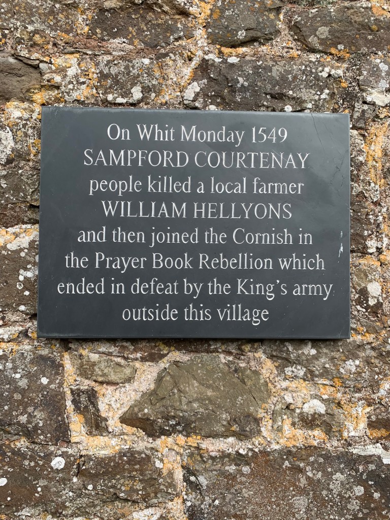
On Whitsunday 1549 the prayer book in English was introduced. On Whitmonday the Parishioners of Sampford Courtenay forced their priest to revert to the latin format. At the next service Justices came to enforce the change. An argument ensued which ended in William Hellyons, a proponent of the change, being killed on the church house steps, sparking the revolt.
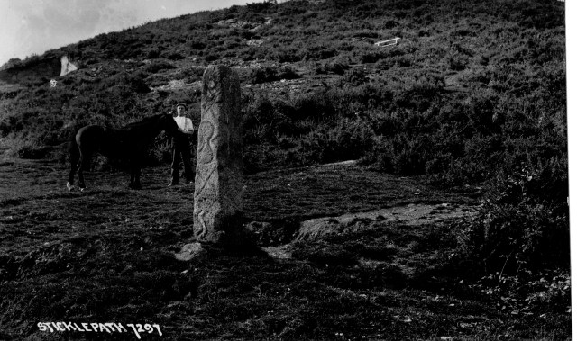
Perhaps more significant for Sticklepath village itself were the Wesleys’ visits to the Quakers, a dominant group in the village in the mid-18th century. The flag pole and ‘White Rock’ up on the mount looking down over Sticklepath mark the place John Wesley is said to have preached. The rock continues to be painted and the anniversaries are marked. Wesleyan Methodism was well supported in the village throughout the 19th century and until the late 20th century. The separation from Sampford Courtenay and establishment of Sticklepath Parish in the 1980s was another key moment.
Looking forward: Knowledge of the landscape also helps planners and conservationists consider how best to manage and enhance its future whilst preserving its heritage. In these days of increased leisure, paths previously necessary for workers and pack horses might find a new meaning. The recently launched Archangel Way (July 2021) , a 35 mile long Pilgrimage walk from St Michael Church on top of Brentor to St Michael the Archangel church in Chagford, is one example. Longer ago I recall the launch of the Tarka Trail in 1987, the Southern loop of which crosses the Taw behind the Foundry in Sticklepath. A very pleasant walk can be found from the bridge at one end of the village, along the far side of the Taw, returning along the valley road from Belstone for example. Wildlife too, such as the hares trapped 120 years ago to feed the hungry poor, now attract tourists and time spent on Dartmoor in a natural environment has been given a new value in helping our mental well-being.
The concept of #OnePlaceEnvironment is complex incorporating not just the landscape but many aspects, such as the social and political context, which have not been touched on here. Herring (3) says
“The definition of landscape developed for the European Landscape Convention (in force in the UK since March 2007) catches the more democratic and cognitive approaches of historic landscape characterisation. That is to say it is cognitive pertaining to perception, memory, judgement and reasoning: ‘‘An area, as perceived by people, whose character is the result of the action and interaction of natural and/ or human factors’’ (Council of Europe, 2000; Fairclough, 2002).”
Just as the history of a battle is usually written by the victors, historic evidence is biased, usually more influenced by the higher social classes. These ‘One-Place’ environment ramblings are a subjective, personal and incomplete assessment, coloured greatly by my own experiences, memory and knowledge. As this One-Place Study progresses I hope to enrich and deepen that understanding of the historic environment.
Bibliography.
- Provincial England: Essays in Social and Economic History by WG Hoskins 1963. London, MacMillan & Co.Ltd.
- Ancient Country: The Historical Character of Rural. Devon by Sam Turner. Devon Archaeological Society Occasional Paper 20. 2007
- Framing Perceptions of the HistoricLandscape: Historic LandscapeCharacterisation (HLC) and HistoricLand-Use Assessment (HLA) Peter Charles Herring Scottish Geographical Journal Vol. 125, No. 1, 61–77, March 2009
- Secondary sources used primarily: South Tawton & South Zeal – with Sticklepath 1000 years beneath the beacon. Roy and Ursula Radford 2000. Halsgrove. (Note: Examination of primary sources is a long term aim. Manorial records for Sticklepath are at Devon archive. King’s College, landowners for much of the area, have further records in Cambridge.)
- https://www.dartmoor.gov.uk/__data/assets/pdf_file/0031/78583/Sticklepath-R6.compressed.pdf